
11 - 20 of 139
subsurface imaging geophysical sensor
Selling leads

|
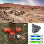
... geophysical equipment built primarily for subsurface studies. It uses lead synchronization technology to increase the detection range, integrates ...
2026-06-19 00:09:46
|

|
...subsurface environment. These measurements are critical for understanding the geology, fluid flow, and borehole integrity in a particular location. ...
2025-05-29 16:32:06
|
|
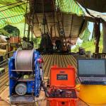
... method used to determine the electrical resistivity of subsurface materials to a depth of several hundred meters. With injected DC current into ...
2025-05-29 16:31:00
|

|
..., and fails to optimize crop yield. Our Precision Agriculture and Root Zone Hydrogeophysics Platform addresses this challenge by bringing high...
2026-05-23 00:35:23
|
|
WDJD-4A: Mitigate Investment Risk with Subsurface Certainty Protect financial investments with defensible subsurface data. This commercial assessment ...
2026-06-19 00:09:46
|
|
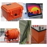
Borehole Geophysical Subsurface Borehole Logging Tools Up To 1000m Depth Borehole logging tool can obtain the geophysical data in the borehole to the ...
2025-05-29 16:31:33
|
|
... scientists, renewable energy pioneers, and conservation warriors, this tool doesn’t just inspect—it protects our planet’s fragile subsurface ...
2026-06-19 00:09:46
|

|
...t support probabilistic analysis and risk assessment. The GD-C1201 Intelligent Drillhole Optical Imager functions as a statistical characterization ...
2026-06-19 07:30:43
|
|
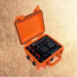
...Electrode Water Detection System Resistivity Imaging for Geology Resistivity Survey Main Application The WDA-1 Super Digital DC Electric Instrument ...
2026-06-19 00:09:46
|
|
... of the subsurface. The data collected from seismic surveys is used to create images of the subsurface, which can help geologists and engineers ...
2024-12-09 22:21:14
|