
1 - 10 of 215
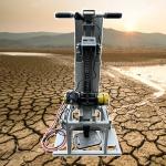
geophysical exploration instrument
Selling leads

|
The Statistical Subsurface Characterization Tool Modern geotechnical and resource models thrive on quantitative data—not just visual descriptions but ...
2026-06-19 07:30:43
|

|
Earthquake Fault Magnetotellurometer Infrastructure Site Magnetotellurometer GD-5 Magnetotelluric System: Building Geophysical Competence Through ...
2026-06-19 00:09:46
|

|
DZD-8 Multi-function Full Wave DC Electron Meter Environmental site assessments demand defensible data. The DZD-8 Multi-function Full Wave DC Electron ...
2026-06-19 00:09:46
|

|
GYGD-IV Rotary Borehole Inspection Camera: Exploring Underground History Without Disturbing It Archaeologists and cultural heritage managers often ...
2026-06-19 00:09:46
|
|
Keep Your Crew Moving: The GD-600 Rapid-Fire Seismic Source For geophysical service providers billing by the kilometer, shot cycle time is money. The ...
2026-06-19 00:09:46
|

|
Measurement Integrity from Electrode Contact to Final Section Subsurface interpretation quality depends fundamentally on raw data integrity. This ...
2026-06-19 00:09:46
|

|
Dam Seepage Resistivity Tool Archaeology Resistivity Mapper What Lies Beneath? The WGMD-4 Answers the Questions That Matter As a consultant, your ...
2026-06-19 00:09:46
|

|
Intrinsically Safe Level Probe Remote Water Level Telemetry Agricultural Tile Drainage Flow and Water Table Management System Subsurface tile drainage ...
2026-06-19 00:09:46
|

|
Seismic Source System Engineering Seismic Source Maximum Value Per Shot: The GD-600 Economical Seismic Source Small and mid-sized geophysical firms ...
2026-06-19 00:09:46
|

|
2D Resistivity Tomography Instrument 3D Subsurface Resistivity Scanner WDJD-4A: Uncompromised Geophysical Performance in the Planet's Most Hostile ...
2026-06-19 00:09:46
|