
1 - 10 of 137
subsurface imaging geophysical sensor
Selling leads

|
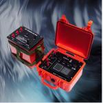
Next-Generation Geophysical Imaging with Smart Features Embrace the future of subsurface characterization with this AI-enhanced geophysical platform ...
2025-08-29 08:07:29
|
|
WDDS-3C: Ensuring Water Access Through Advanced Technology Addressing global water challenges requires innovative solutions, and the WDDS-3C stands at ...
2025-08-28 13:58:28
|

|
Intelligent 2D Geophysical Exploration Instrument for Resistivity Imaging Main Function WGMD-9 super digital DC resistivity/IP meter is a newly ...
2024-12-09 22:21:14
|
|
2/3D Resistivity&IP imaging instrument geophysical exploration for underground Maximum transmitting powe 7200W Maximum supply voltage 1200V (with WDZJ...
2024-12-09 23:37:26
|

|
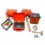
GD-5 Magnetotelluric System: Responsible Exploration for a Better Tomorrow Modern resource development demands environmental responsibility alongside ...
2026-06-19 00:09:46
|

|
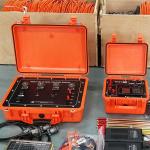
WTEM-3: Pushing Boundaries in Geophysical Science Cutting-Edge Platform for Scientific Discovery Research institutions and innovation laboratories ...
2026-06-19 00:09:46
|
|
... Resistivity Imaging System Electrical Resistivity Imaging System(also named2D ERT) is a non-invasive geophysical method of primary interest for ...
2024-12-09 22:21:14
|

|
...Imaging Technology The Geophysical Resistivity Meter is a state-of-the-art instrument designed for comprehensive subsurface exploration. It ...
2026-06-19 00:09:46
|

|
...Geophysics Tools Seismic Survey Hammer Technical Overview: GD-600 Seismic Source for High-Precision Surveys The GD-600 seismic excitation device ...
2025-05-29 16:32:33
|
|
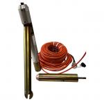
...waves in rock formations. It is designed to be lowered into a borehole or well and can detect seismic waves in three dimensions, allowing for more ...
2024-12-09 22:21:14
|