
Subsurface Geophysical Borehole Logging Tools Up To 1000m Depth
|
|
Borehole Geophysical Subsurface Borehole Logging Tools Up To 1000m Depth
Borehole logging tool can obtain the geophysical data in the borehole to the greatest extent within a few hours, helping users solve many problems encountered in hydrological surveys and groundwater resource exploration, avoiding unnecessary construction costs, thereby solving engineering costs and improving construction efficiency .
Application
1. Determine the rock properties of the well section, evaluate the oil (gas) and water layers, find out coal, metal and non-metal, nuclear metal deposits (see industrial classification of deposits), and determine their burial depth and effective thickness; 2. Measure various geological parameters required for calculating reserves, such as lithological composition, porosity, permeability, saturation, coal ash, carbon content, grade of metal and non-metal ore, water quality and water volume of aquifer, etc. ; 3. Determining the dip angle of the formation, the strike and orientation of the rock stratum, and the dip angle and azimuth of the drilling hole; 4. Check the downhole technical conditions, such as checking the cementing quality and casing rupture.
Technical Specification
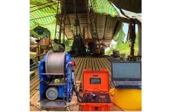
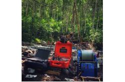
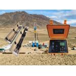
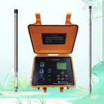
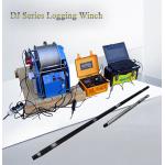
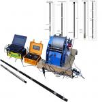
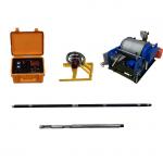
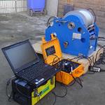
Product Display
|
|||||||||||||||||||||||||||||||||||||||||||||
| Product Tags: Subsurface Borehole Logging Tools Borehole Logging Tools Geophysical Logging Tools | |||||||||||||||||||||||||||||||||||||||||||||
|
GDQ-2D Well Casing Inspection Tool with Real-Time Data Sync |
|
Groundwater Geophysical Well Logging Monitor Borehole Logging Equipment |
|
High Stability Geological Automatic Controlled High Speed Electrical Lifting Winch With Low Price |
|
Portable Water Geophysical Well Logging Borehole Logging Equipment |
|
Groundwater Geophysical Well Logging Monitor Borehole Logging Equipment |
|
Multi Parameter Electric Geophysical Wireline Logging For Water Well Survey |