Global food security in an era of water scarcity demands a
revolution in agricultural water management. The traditional
approach of irrigating uniform fields based on average conditions
wastes water, leaches nutrients, and fails to optimize crop yield.
Our Precision Agriculture and Root Zone Hydrogeophysics Platform
addresses this challenge by bringing high-resolution subsurface imaging directly to the farm gate, providing growers with the intelligence to manage water and
nutrients with unprecedented precision. This system integrates mobile resistivity mapping, soil moisture profiling, and real-time
data analytics to characterize the spatial variability of soil properties, root
zone water storage, and infiltration pathways across entire fields,
enabling variable rate irrigation, targeted nutrient management, and early
detection of drainage or salinity issues that degrade productivity.
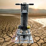
The platform’s field-deployable component is a towed resistivity array specifically designed for agricultural conditions. The lightweight,
low-draft array is pulled behind a farm vehicle (tractor, ATV, or
utility vehicle) at speeds up to 10 km/h, acquiring continuous
resistivity profiles of the root zone (0-2 meters depth) and deeper
subsoil (2-5 meters). The system’s depth-of-investigation control allows the operator to focus on the root zone of the specific crop,
providing detailed maps of available water holding capacity, clay
lenses that impede drainage, and sandy zones that lose water and
nutrients rapidly. The array operates through standing stubble,
residue, and moderate crop canopies, enabling in-season surveys
that capture changing conditions without damaging plants.
The core analytical product is the Root Zone Water Holding Capacity (RZWHC) map, derived from the resistivity data through petrophysical
transformation calibrated to local soil texture. This map
quantifies, at 5-10 meter spatial resolution, the volume of
plant-available water stored in the active root zone. For variable
rate irrigation systems (center pivots with individual sprinkler
control), the platform generates prescription maps that specify the optimal irrigation rate for every location in the
field, accounting for local differences in soil water storage. The
result is water savings of 20-40% compared to uniform application,
while maintaining or increasing yield by eliminating
under-irrigated zones and reducing over-irrigation that leaches
nutrients below the root zone.
The platform’s salinity and drainage monitoring module identifies emerging problems before they cause irreversible yield
loss. Resistivity is highly sensitive to soil salinity, with
conductive signatures indicating elevated salt concentrations. The
system distinguishes between salinity (uniformly conductive
throughout the profile) and water content variations (conductivity
changes with depth in patterns that follow wetting fronts).
Time-lapse surveys repeated after irrigation or rainfall events
track the movement of salts through the profile, identifying areas where leaching is effective and where salts are
accumulating. For tile-drained fields, the system maps the pattern
of water extraction, detecting blocked or collapsed tiles as
anomalous dry or wet zones. This intelligence enables targeted
remediation—selective tile replacement, deep tillage to break
hardpans, or changes in irrigation practice—before widespread
damage occurs.
Agricultural Imaging Platform: Technical Specifications
The platform’s in-season monitoring capability supports adaptive management as growing conditions evolve. Early in
the season, surveys map the soil water status prior to planting,
informing planting decisions and initial irrigation setup.
Mid-season surveys identify developing moisture stress, drainage
problems, or salinity accumulation, allowing corrective action when
it can still benefit the current crop. Post-harvest surveys
evaluate the effectiveness of the season’s management and guide
fall or winter practices (cover cropping, deep tillage, soil
amendments). This continuous improvement cycle builds year-on-year understanding of field variability, refining
prescription maps and management strategies over time.
Data integration with existing farm management systems is seamless.
The platform exports results in standard formats (Shapefile, GeoJSON, CSV) for use in major precision ag software (Operations Center, Climate
FieldView, AgLeader SMS). Prescription maps can be wirelessly
transferred to variable rate controllers for immediate
implementation. The cloud-based dashboard provides a secure,
accessible repository of all field data, accessible from the farm
office, the tractor cab, or a smartphone. Real-time alerts notify
growers of detected anomalies—sudden wetting that might indicate a
pipe leak, or a developing salinity hotspot—enabling immediate
investigation and response.
Designed for progressive growers, agronomists, and crop
consultants, the platform includes training and ongoing support tailored to agricultural operations. Field staff learn to operate
the system, interpret results, and integrate outputs into their
existing workflow. Technical support is available during growing
season hours, recognizing the time-sensitive nature of agricultural
decisions. The platform thus serves not as a one-time survey tool
but as an ongoing intelligence partner for the precision agriculture journey.
In essence, the Precision Agriculture and Root Zone Hydrogeophysics
Platform brings the power of modern geophysics to the farm,
democratizing access to the subsurface intelligence that has long
been available only to mining and groundwater professionals. By
revealing the hidden variability in soil water holding capacity,
drainage, and salinity, it empowers growers to manage their most
precious resource—water—with the precision, efficiency, and
foresight that the 21st century demands. It is a tool not just for
growing crops, but for growing a sustainable agricultural future.