
81 - 88 of 88
gairhawk uav lidar system
Selling leads
|
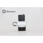
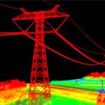
... LiDAR point cloud data acquisition system, integrated HESAI XT laser scanner, GNSS and IMU positioning and attitude determination system, and ...
2025-07-25 11:54:18
|
|
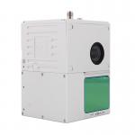
Forestry Surveying Drone LiDAR Geosun GS-260X Aerial Mapping Solution Geosun gAirHawk Series GS-260X Drone LiDAR Scanning System gAirHawk GS-260X is a ...
2025-07-29 00:11:05
|
|
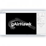
... gAirHawk 5.0 is a powerful LiDAR data acquisition and pre-processing software independently developed by Geosun Navigation. Designed for use with ...
2025-07-25 11:56:11
|
|
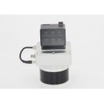
...LiDAR System Geosun GS-100C+ Aerial Mapping Survey High Precision IMU Coloured Point Cloud Geosun Thailand partner have a on-site trainning at ...
2025-07-29 00:11:05
|
|
...LiDAR Scanning System Geosun GS-260X PPK RTK Processing Geosun gAirHawk Series GS-260X Drone LiDAR Scanning System Drone LiDAR Scanning System GS...
2025-07-29 00:11:05
|
|
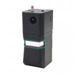
Compact Multispectral Camera LiDAR Scanning System For Forestry gAirHawk GS-130D is a kind of short-range, compact LiDAR point cloud data acquisition ...
2025-07-25 11:54:18
|
|
...GS-960 is a cutting-edge high-precision UAV LiDAR scanning system developed by Geosun Navigation. Its integrated design combines surveying-grade ...
2025-07-25 11:55:03
|
|
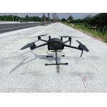
...LiDAR Drone Safety Aircraft Aerial Survey Operation Support GS-800 multi-rotor UAV aerial photographing and mapping system is made of high-strength ...
2025-07-25 11:55:21
|