China LiDAR Scanning System manufacturer
Wuhan Geosun Navigation Technology Co., Ltd.
Geosun's Wishes and Aspirations: Make the LiDAR/SLAM Solution More Applicable and Affordable
5
Home > Products > Airborne Mapping Payload >

University Cooperation LiDAR Drone Scanner Geosun GS-100C+ High Precision IMU Colour

Browse Categories

Wuhan Geosun Navigation Technology Co., Ltd.

City: wuhan

Province/State:hubei

Country/Region:china

Tel:+86--15527360208

Contact Person:
Mr.Lanbooxie
View Contact Details

University Cooperation LiDAR Drone Scanner Geosun GS-100C+ High Precision IMU Colour

Brand Name Geosun
Model Number GS-100C+
Certification CE,ISO
Place of Origin China
Minimum Order Quantity 1
Price Negotiation
Supply Ability 80 SETS/Month
Delivery Time 10-15 works days
Packaging Details Suit Case 450*365*200 mm
Item Name LiDAR Scanning System
Operation Efficiency: 1.92 Km2 / Single Flight
Application Topography, Smart City
Numbers of returns Triple-echo
Accuracy 10cm@100m
Dimension 13.8*9.1*9.4cm
Weight 1015g
Storage 64GB Max Support 128GB TF card
Working Temperature -20°~+55°
Carrying Platform Multi-Rotor/VTOL
Trajectory Software Shuttle
Point Cloud Software gAirHawk
Detailed Product Description

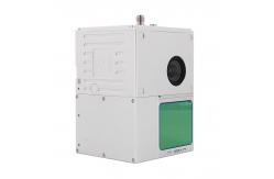
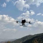
                             University Cooperation LiDAR System Geosun GS-100C+ Aerial Mapping Survey High Precision IMU Coloured Point Cloud

Geosun Thailand partner have a on-site trainning at university for uav LiDAR scanning system GS-100C+.

uav LiDAR scanning system GS-100C+ is the most affordable uav lidar scanning system choice to start aerial mapping because of its full function.

The most popular laser sensor Livox avia, high accuracy IMU and built-in RGB camera work together for excellent performance on different applications of surveying. GS-100C+ LiDAR Scanning System Brochure.pdf

Application of UAV LiDAR Scanning System

Free Trial Software UAV LiDAR Scanning System

Trial Software Information.pdf

Point Cloud Pre-Processing Software Integrated With Trajectory Processing----Geosun Self-developed gAirHawk 5.0
Key Features of gAirHawk 5.0 Software
1. Raw data: intelligently load
2. Four default coordinates
3. Point cloud Optimization
4. Start and stop calculation
Free trial test, achieve high precision

Specification of UAV LiDAR Scanning System

uav LiDAR scanning system gAirHawk GS-100C+
 Item NameSystem Parameter


GS-100C+

Parameter

Weight1025g
Measuring accuracyLess than 10 cm (110 m AGL)
Power range12V~16V
Working temperature-20℃~+55℃
ConsumptionAverage 20W
Support PlatformMulti Rotor, VTOL Fixed Wing
Storage64 GB storage, maximum support 128GB TF card

Lidar Unit


Laser ModelLivox Avia
Measuring Range190m@10% Reflectivity
Laser class905nm Class1 (IEC 60825-1:2014)
Laser line numberEquivalent to 64-beam
Mix. range0.3 M
Range Precision2 cm
dataTriple echo, 720,000 Points/Sec
FOV70° the circular view
POS UnitUpdate frequency200HZ
Heading accuracy0.040°
Pitch accuracy0.015°
Rolling accuracy0.015°
Position accuracy0.02 - 0.05m
GNSS signal typeGPSL1/L2/L5 GLONASSL1/L2 BDS B1/B2/B3 GAL E1/E5a/5b
Pre-processing softwarePOS softwareOutput information: position, speed, attitude
Point cloud softwareOutput point cloud data format: LAS format, custom TXT format
Built-in CameraFOV83 Degree
Effective Pixel26 Mega Pixel
Focal Lenght(mm)16


Package of uav LiDAR Scanning System

UAV LiDAR Scanning System is packed by suit case with EVA material liner inside, then covered by hard carton box.

The pacakge of uav LiDAR scanning system is suitable for air shipment and sea shipment.


Product Tags: LiDAR Drone Scanner Geosun   GS-100C+ LiDAR Drone Scanner   High Precision lidar 3d scanner  
Related Products
Email to this supplier
 
From:
Enter your Email please.
To: Wuhan Geosun Navigation Technology Co., Ltd.
Subject:
Message:
Characters Remaining: (80/3000)