
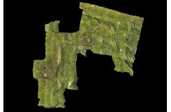
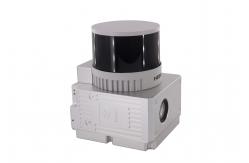
Forestry Surveying Drone LiDAR Geosun GS-260X Aerial Mapping Solution
|
|
Forestry Surveying Drone LiDAR Geosun GS-260X Aerial Mapping Solution
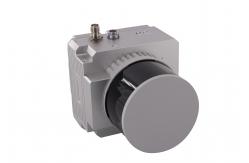
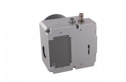
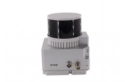
Geosun gAirHawk Series GS-260X Drone LiDAR Scanning System For more specification please check here: gAirhawk GS-260X.pdf
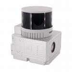
Specification of Drone LiDAR Scanning system GS-260X
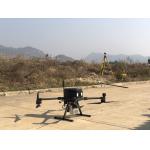
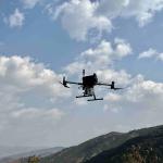
GS-260X Drone LiDAR Scanning System Application
Free trial software of Drone LiDAR Scanning System The Guideline of LiDAR Usage and Reference.pdf Point Cloud Pre-Processing Software Integrated With Trajectory
Processing----Geosun Self-developed gAirHawk 5.0
Package of Drone LiDAR Scanning System GS-260X Drone LiDAR scanning system GS-260X is packed by suit case with EVA material liner inside, then covered by hard carton box. The package of LiDAR scanning system is suitable for air shipment and sea shipment.
|
|||||||||||||||||||||||||||||||||||||||||||||||||||||||||||||||
| Product Tags: Forestry Surveying Lidar Drone Scanner Lidar Drone Scanner PPK Mode Lidar For 3D Scanning DEM Output | |||||||||||||||||||||||||||||||||||||||||||||||||||||||||||||||

|
Terrain Mapping Aerial Surveying Geosun UAV LiDAR System GS-130X High Precision |

|
GS-100V UAV LiDAR System 360 Degree Fov Laser Sensor Colored Point Cloud Free Software |
|
AirPort Construction UAV LiDAR GS-260X High End Pos Built In RGB Camera |

|
GAirHawk Series GS-2000N LiDAR Scanning System Long Detection Airborne Mapping |
|
Geosun GAirHawk Series GS-260X UAV LiDAR Scanning System HESAI XTM2X Sensor |
|
Terrain Mapping GS-260X UAV LiDAR Scanning System HESAI Sensor |