
111 - 120 of 139
subsurface imaging geophysical sensor
Selling leads
|
GDQ-2D: Your Unified Hub for Subsurface Intelligence Stop juggling incompatible tools. Our system seamlessly connects with your existing GIS, CAD, and ...
2026-06-19 00:09:46
|

|
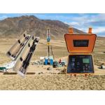
Centralized Multi - electrode Resistivity Survey System for Engineering Geology Projects Centered around WDA - 1, this system uses centralized cable ...
2026-06-19 00:09:46
|

|
WZG-24C/48C Seismograph: Driving the Sustainable and Ethical Supply Chain for the Energy Transition Powering the Green Revolution with Responsible ...
2026-06-19 00:09:46
|

|
Intrinsically Safe Level Probe Remote Water Level Telemetry Agricultural Tile Drainage Flow and Water Table Management System Subsurface tile drainage ...
2026-06-19 00:09:46
|

|
Dam Seepage Resistivity Tool Archaeology Resistivity Mapper What Lies Beneath? The WGMD-4 Answers the Questions That Matter As a consultant, your ...
2026-06-19 00:09:46
|

|
GYGD-IV Rotary Borehole Inspection Camera: Exploring Underground History Without Disturbing It Archaeologists and cultural heritage managers often ...
2026-06-19 00:09:46
|

|
...absolute precision and comprehensive environmental mastery. This advanced system provides unmatched control and detailed understanding of ...
2026-06-19 00:09:46
|
|
... of a camera and a light source mounted on a probe that is lowered into the borehole. The probe also contains sensors that measure the orientation ...
2024-12-09 22:21:14
|
|
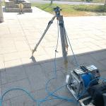
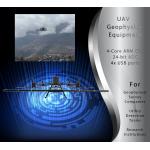
...geophysics, mining, or utility detection, you know how important accurate magnetic surveys are. Unlike traditional ground surveys (which are slow ...
2025-08-29 06:12:48
|
|
...subsurface by generating and recording signals that travel through the earth. These signals can be used to create images and maps of the undergroun...
2026-06-19 00:09:46
|