
51 - 60 of 114
multi function geophysical exploration tool
Selling leads
|
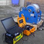
...Geophysical Subsurface Borehole Logging Tools Up To 1000m Depth Borehole logging tool can obtain the geophysical data in the borehole to the ...
2025-05-29 16:31:33
|
|
"Carbon-Negative Exploration: How Our Tool Heals Earth While Mapping It" Traditional gear guzzles diesel. The WDA-1A runs on sunlight and genius. Its ...
2025-06-25 00:09:25
|

|
Next-Generation Geophysical Imaging with Smart Features Embrace the future of subsurface characterization with this AI-enhanced geophysical platform ...
2025-08-29 08:07:29
|

|
One system, endless applications across multiple industries. Engineered for remarkable versatility, this platform adapts seamlessly to diverse ...
2025-10-31 00:18:31
|
|
Oil Well Logging Equipment geophysical well logging equipment plays a crucial role in the oil and gas exploration process, providing geoscientists and ...
2025-05-29 16:32:09
|

|
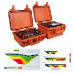
The Statistical Subsurface Characterization Tool Modern geotechnical and resource models thrive on quantitative data—not just visual descriptions but ...
2026-06-19 07:30:43
|
|
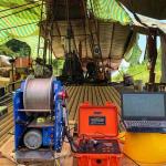
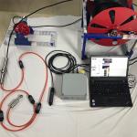
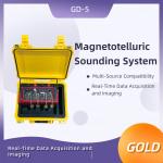
..., this system integrates broadband electromagnetic sounding (10kHz–10000s) with multi-method compatibility (HMT, AMT, BMT, MT, CSAMT, TEM, IP). Its ...
2025-05-29 16:32:23
|
|
Wireline Multi -Parameter Geophysical Well Logging For Water Well Survey How to use geophysical well logging tool? 1. The instrument should be placed ...
2026-06-19 00:09:46
|
|
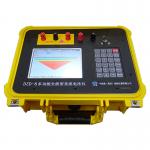
DZD-8 top Multi Parameter Water tester DC resisitivity meter for groundwater a cutting-edge geophysical survey instrument designed to optimize your ...
2024-12-10 00:29:34
|
|
Advanced resistivity Meter with Precise Measurement tools instruments for investigating groundwater Bluetooth technology, wireless remote control: The ...
2026-06-19 00:09:46
|