
91 - 96 of 96
uav lidar scanning system
Selling leads

|
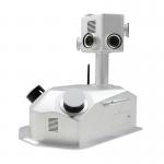
2.1kg 20W HESAI Pandar 40P airborne 3D Mapping Drone LiDAR Geosun GS-260F Geosun gAirHawk Series GS-260F Drone LiDAR Scanning System gAirHawk GS-260F ...
2025-07-27 00:13:17
|
|
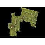
Forestry Surveying Drone LiDAR Geosun GS-260X Aerial Mapping Solution Geosun gAirHawk Series GS-260X Drone LiDAR Scanning System gAirHawk GS-260X is a ...
2025-07-27 00:13:17
|
|
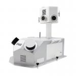
gCollector-M302 Road Information Collection LiDAR Scanning System The gCollector-M302 Road Information Collection system is a mobile real scense ...
2025-07-27 00:13:17
|
|
gCollector-M502 Road Information Collection LiDAR Scanning System The gCollector-M502 Road Information Collection system is a mobile real scense ...
2025-07-27 00:13:17
|
|
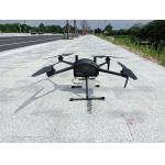
...LiDAR Drone Safety Aircraft Aerial Survey Operation Support GS-800 multi-rotor UAV aerial photographing and mapping system is made of high-strength ...
2025-07-25 11:55:21
|
|
... gAirHawk 5.0 is a powerful LiDAR data acquisition and pre-processing software independently developed by Geosun Navigation. Designed for use with ...
2025-07-25 11:56:11
|