
51 - 60 of 78
road mapping lidar 3d scanner
Selling leads

|
...Mapping GS-100V UAV LiDAR Scanning System 360 Degree Fov Laser Sensor Colored Point Cloud Free Software Geosun gAirHawk LiDAR Scanning System GS...
2025-08-01 00:11:51
|
|
Long Range Laser Scanning VTOL UAV Vehicle Supported Five Echo Colored Point Cloud Free Trajectory Processing gAirHawk GS-1350W is a kind of long ...
2025-08-01 00:11:51
|
|
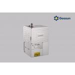
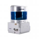
Geosun GFireEye Series GS-130G SLAM LiDAR HESAI XT32 Slam Algorithms Indoor Outdoor Mapping 3D Data Collection Geosun gFireEye Series GS-130G SLAM ...
2025-08-01 00:11:51
|
|
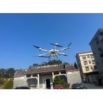
UAV LiDAR System Geosun gAirHawk GS 130H DJI M600 Pro Livox Horizon LiDAR Drone LiDAR Scanning System Mounted on DJI M600 Pro , Forestry Application ...
2025-08-01 00:11:51
|

|
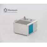
... GS-120G SLAM HESAI XT32 Slam Algorithms Indoor/Outdoor Mapping 3D Data Collection Geosun gFireEye Series GS-120G SLAM LiDAR GS-120G is a kind of ...
2025-08-01 00:11:51
|
|
..., it captures precise 3D point clouds in GNSS or GNSS-denied environments. Its compact design ensures easy mobility for indoor and outdoor mapping, ...
2025-07-25 11:56:20
|

|
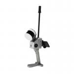
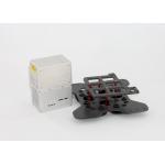
... of handheld LiDAR scanning system independently developed by Geosun company.It adopts a simple design with a small body, so as to be light to ...
2025-08-01 00:11:51
|
|
gAirHawk GS-2000R LIDAR SCANNING SYSTEM Long Range LiDAR Scanning System with Riegl Laser Sensor gAirHawk GS-2000R is a kind of long range, compact ...
2025-07-25 11:53:59
|
|
gAirHawk GS-260P LIDAR SCANNING SYSTEM Drone LiDAR Scanning System mounted on DJI M600 Pro Application for Terrain Survey gAirHawk GS-260P is a kind ...
2025-08-01 00:11:51
|
|
... system, integrated HESAI Pandar laser scanner, GNSS and IMU positioning and attitude determination system, and storage control unit, is able to ...
2025-08-01 00:11:51
|