
Long Range LiDAR solution 1cm Accuracy Riegl UAV LiDAR GS-2000R
|
|
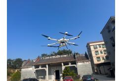
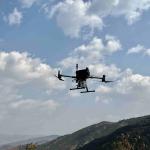
gAirHawk GS-2000R LIDAR SCANNING SYSTEM Long Range LiDAR Scanning System with Riegl Laser Sensor gAirHawk GS-2000R is a kind of long range, compact LiDAR point cloud data acquisition system, integrated Riegl laser scanner, GNSS and IMU positioning and attitude determination system, and storage control unit, is able to real-time, dynamically, massively collect high-precision point cloud data and rich image information. It is widely used in the acquisition of 3D spatial information in surveying, electricity, forestry, agriculture, land planning.GS-2000R LiDAR Scanning System.pdf
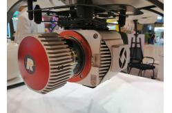
The RIEGL VUX-1LR-22 is a very lightweight and compact laser scanner, meeting the
challenges of emerging survey solutions by UAS/UAV/RPAS both in
measurement performance as well as in system integration. With
regard to the specific constraints and flight characteristics of
the UAS, the RIEGL VUX-1LR-22 is designed to be mounted in any orientation and even under
limited weight and space conditions. Modest in power consumption,
the instrument requires only a single power supply. The entire data
set of an acquisition campaign is stored onto an internal 240 GByte
SSD and/or provided as real-time line scan data via the integrated
LAN-TCP/IP interface.
Feature 15 mm survey-grade accuracy scan speed up to 200 scans / second measurement rate up to 1,500,000 meas./sec (@ 1500 kHz PRR & 360° FOV) operating flight altitude more than 3,440 ft field of view up to 360° for practically unrestricted data acquisition regular point pattern, perfectly parallel scan lines cutting edge RIEGL technology providing multiple target capability - up to 15 targets echoes compact (227x180x125 mm), lightweight (3.5 kg), and rugged easily mountable to manned helicopters, gyrocopters, and other small manned aircrafts mechanical and electrical interface for IMU mounting electrical interfaces for GPS data string and Sync Pulse (1PPS) LAN-TCP/IP interface internal data storage on Solid State Disc SSD, 1 TByte
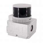
Specification of LiDAR Scanning System gAirHawk GS-2000R
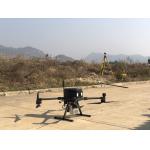
Application for Forestry Survey
Package It is packed by suit case with EVA material liner inside, then covered by hard carton box. It is suitable for air shipment and sea shipment.
|
|||||||||||||||||||||||||||||||||||||||||||||||||||||||||||||||||
| Product Tags: Long Range 1000ft Flight UAV LiDAR Long Range Riegl UAV LiDAR 1cm Accuracy riegl lidar | |||||||||||||||||||||||||||||||||||||||||||||||||||||||||||||||||

|
Terrain Mapping Aerial Surveying Geosun UAV LiDAR System GS-130X High Precision |

|
GS-100V UAV LiDAR System 360 Degree Fov Laser Sensor Colored Point Cloud Free Software |
|
AirPort Construction UAV LiDAR GS-260X High End Pos Built In RGB Camera |

|
GAirHawk Series GS-2000N LiDAR Scanning System Long Detection Airborne Mapping |
|
Geosun GAirHawk Series GS-260X UAV LiDAR Scanning System HESAI XTM2X Sensor |
|
Terrain Mapping GS-260X UAV LiDAR Scanning System HESAI Sensor |