
11 - 20 of 90
gs 2000n lidar scanning system
Selling leads
|
Geosun GS-260H UAV LiDAR Aerial Mapping Drone Surveying City Construction 3D Modeling Geosun gAirHawk LiDAR Scanning System GS-260H gAirHawk GS-260X ...
2025-07-29 00:11:05
|
|
Mobile LiDAR Mapping 3D Spatial Data Collecting 905nm HESAI Laser Sensor Geosun gAirHawk Series Mobile LiDAR Scanning System GS-130X gAirHawk GS-130X ...
2025-07-25 11:53:25
|
|
...Surveying HESAI Pandar40p Laser Scanner Geosun GS-260F UAV LiDAR Scanning System LiDAR Scanning System with HESAI Pandar Laser Sensor Mounted on ...
2025-07-29 00:11:05
|
|
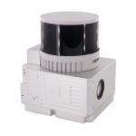
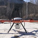
Land Surveying Vtol LiDAR Long Detection Geosun gAirHawk GS-2000N Geosun gAirHawk Series uav LiDAR Scanning System GS-2000N UAV LiDAR Scanning System ...
2025-07-29 00:11:05
|
|
... Mapping Long Range Detection LiDAR Scanning Support VTOL Airborne High Accuracy DEM Geosun gAirHawk Series GS-2000N UAV LiDAR Scanning System UAV ...
2025-07-29 00:11:05
|

|
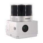
...GS-260H UAV LiDAR Scanning System HESAI XTM2X Sensor High Acuraccy Geosun gAirHawk Series GS-260H UAV LiDAR Scanning System The GS-260H features a ...
2025-07-25 11:53:40
|
|
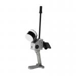
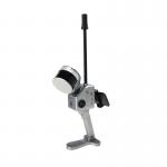
... of handheld LiDAR scanning system independently developed by Geosun company.It adopts a simple design with a small body, so as to be light to ...
2025-07-29 00:11:05
|
|
...GS-2000R LiDAR Scanning System High Accuracy Colored Point Cloud Long Detection Airborne Mapping Geosun gAirHawk Series GS-2000R LiDAR Scanning ...
2025-07-25 11:55:05
|
|
... GFireEye Series GS-100G SLAM LiDAR Scanning System HESAI XT16 Slam Algorithms Under Ground Mapping 3D Data Collection Geosun gFireEye Series GS...
2025-07-29 00:11:05
|

|
...LiDAR Scanning System Geosun GS-130X Colored Point Cloud High Accuracy Geosun gAirHawk Series GS-130X Drone LiDAR Scanning System Drone LiDAR ...
2025-07-29 00:11:05
|