
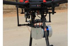
Drone Surveying HESAI Pandar40p Laser Scanner Geosun GS-260F LiDAR Scanning System
|
|
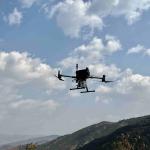
Drone Surveying HESAI Pandar40p Laser Scanner Geosun GS-260F UAV LiDAR Scanning System
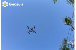
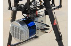
LiDAR Scanning System with HESAI Pandar Laser Sensor Mounted on DJI M600 Pro gAirHawk GS-260F is a kind of Mid-range, compact LiDAR point cloud data acquisition system, integrated HESAI Pandar 40P laser scanner, GNSS and IMU positioning and attitude determination system, and storage control unit, is able to real-time, dynamically, massively collect high-precision point cloud data and rich image information. It is widely used in the acquisition of 3D spatial information in surveying, electricity, forestry, agriculture, land planning.
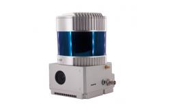
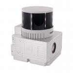
Pandar40P 40-Channel Mechanical LiDAR
Geosun GS-260F UAV LiDAR Scanning System Specification
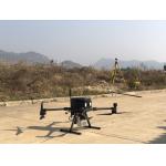
Geosun GS-260F UAV LiDAR Scanning System Application for Mine Capacity Measurement
Free Trial Software UAV LiDAR Scanning System gAirHawk GS-260F Free trial test, achieve high precision The Guideline of LiDAR Usage and Reference.pdf Point Cloud Pre-Processing Software Integrated With Trajectory
Processing----Geosun Self-developed gAirHawk 5.0
Geosun GS-260F UAV LiDAR Scanning System Package Geosun GS-260F UAV LiDAR Scanning System is packed by suit case with EVA material liner inside, then covered by hard carton box. It is suitable for air shipment and sea shipment.
|
|||||||||||||||||||||||||||||||||||||||||||||||||||||||||||||||||||
| Product Tags: DJI M600 Pro LiDAR Scanning System 40 Beam airborne lidar system GS 260F LiDAR Scanning System | |||||||||||||||||||||||||||||||||||||||||||||||||||||||||||||||||||

|
Terrain Mapping Aerial Surveying Geosun UAV LiDAR System GS-130X High Precision |

|
GS-100V UAV LiDAR System 360 Degree Fov Laser Sensor Colored Point Cloud Free Software |
|
AirPort Construction UAV LiDAR GS-260X High End Pos Built In RGB Camera |

|
GAirHawk Series GS-2000N LiDAR Scanning System Long Detection Airborne Mapping |
|
Geosun GAirHawk Series GS-260X UAV LiDAR Scanning System HESAI XTM2X Sensor |
|
Terrain Mapping GS-260X UAV LiDAR Scanning System HESAI Sensor |