
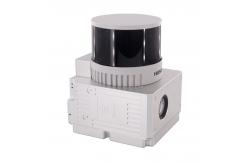
Geosun GAirHawk Series GS-260H UAV LiDAR Scanning System HESAI XTM2X Sensor
|
|
Geosun GAirHawk Series GS-260H UAV LiDAR Scanning System HESAI XTM2X Sensor High Acuraccy
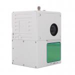
Geosun gAirHawk Series GS-260H UAV LiDAR Scanning System The GS-260H features a 300-meter range, weighs 1.1 kg, and provides 1,920,000 points per second with three returns. It includes a camera for synchronized point cloud and image capture, making it ideal for efficient data collection in mapping, inspections, for- estry, and urban planning. GS-260H LiDAR Scanning System Brochure.pdf
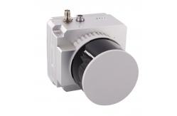
Specification of UAV LiDAR Scanning System gAirHawk GS-260H
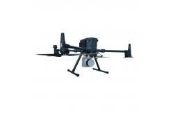
Applications of LiDAR Scanning System gAirHawk GS-260H Geosun technical team is delivering a speech with experts of key labs from Wuhan University, the remote sensing major of which is of leading position on world stage.Geosun is attracting more and more experts' attention. And pressent an accurate mapping in front of LIESMARS building (The State Key Laboratory of Information Engineering in Surveying, Mapping and Remote Sensing)
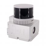
Free Trial Software LiDAR Scanning System gAirHawk GS-260H Free trial test, achieve high precision The Guideline of LiDAR Usage and Reference.pdf Point Cloud Pre-Processing Software Integrated With Trajectory
Processing----Geosun Self-developed gAirHawk 5.0
Package of LiDAR Scanning System gAirHawk GS-260H LiDAR Scanning System gAirHawk GS-260H is packed by suit case with EVA material liner inside, then covered by hard carton box. It is suitable for air shipment and sea shipment.
|
|||||||||||||||||||||||||||||||||||||||||||||||||||||||||||||||
| Product Tags: HESAI XTM2X Sensor LiDAR Scanning System UAV LiDAR Scanning System Geosun GAirHawk Series LiDAR Scanning System | |||||||||||||||||||||||||||||||||||||||||||||||||||||||||||||||

|
GAirHawk Series GS-1500N LiDAR Scanning System 8 Echos Long Detection Aerial VTOL Mapping |
|
Road Mapping High Precision Mobile LiDAR Geosun gAirHawk GS-260X |

|
Geosun gAirHawk Sesries GS-130X LiDAR Scanning System Hesai XT32 Sensor Strong Penetration 360 Degree Fov |

|
Geosun gAirHawk Series GS-2000N LiDAR Scanning System 7 Echos Long Detection Aerial VTOL Mapping High Accuracy |

|
Geosun gAirHawk Series GS-260H LiDAR Scanning System City Construction 3D Modeling High Accuracy Colored Point Cloud |
|
Geosun gAirHawk GS-100C LiDAR Scanning System Skyport DJI M300 Livox Avia Sensor Colored Point Cloud |