
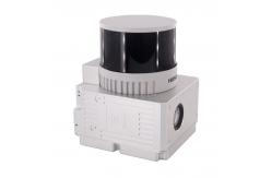
Road Mapping High Precision Mobile LiDAR Geosun gAirHawk GS-260X
|
|
Road Mapping Mobile LiDAR Geosun GS-260X
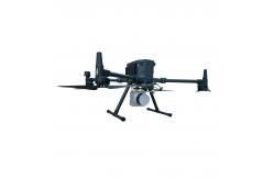
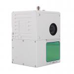
Geosun gAirHawk Sesries GS-260X LiDAR Scanning System gAirHawk GS-260X is a kind of Mid-range, compact LiDAR point cloud data acquisition system, integrated HESAI HESAI XTM2X laser scanner, GNSS and IMU positioning and attitude determination system, and storage control unit, is able to real-time, dynamically, massively collect high-precision point cloud data and rich image information. It is widely used in the acquisition of 3D spatial information in surveying, electricity, forestry, agriculture, land planning.GS-260X LiDAR Scanning System.pdf
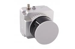
Road Mapping of gAirHawk Sesries GS-260X Mobile LiDAR Scanning System With a quick installation mechanism. Geosun's GS-260X Mobile LiDAR Solution enables you to scan full details around while you are driving. It delivered a report with a point density of 959 points per square meter and a vertical accuracy down to 5mm from a recent test. Even the traffic signs on the ground can be perfectly recognized. Check out yourself through the sample data link: https://drive.google.com/.../1CPtCL9zicc2ykCn197xOzFmIBMQ...
Free Trial of Software LiDAR Scanning System gAirHawk GS-260X Free trial test, achieve high precision The Guideline of LiDAR Usage and Reference.pdf Point Cloud Pre-Processing Software Integrated With Trajectory
Processing----Geosun Self-developed gAirHawk 5.0
Specification of Mobile LiDAR Scanning System gAirHawk GS-260X
Package of Mobile LiDAR Scanning System gAirHawk GS-260X Mobile LiDAR Scanning System gAirHawk GS-260X is packed by suit case with EVA material liner inside, then covered by hard carton box. It is suitable for air shipment and sea shipment.
|
|||||||||||||||||||||||||||||||||||||||||||||||||||||||||||||||
| Product Tags: Road Mapping Lidar 3D Scanner Lidar 3D Scanner Mobile Vehicle High Precision Lidar Scanning Drone | |||||||||||||||||||||||||||||||||||||||||||||||||||||||||||||||

|
GAirHawk Series GS-1500N LiDAR Scanning System 8 Echos Long Detection Aerial VTOL Mapping |
|
Road Mapping High Precision Mobile LiDAR Geosun gAirHawk GS-260X |

|
Geosun gAirHawk Sesries GS-130X LiDAR Scanning System Hesai XT32 Sensor Strong Penetration 360 Degree Fov |

|
Geosun gAirHawk Series GS-2000N LiDAR Scanning System 7 Echos Long Detection Aerial VTOL Mapping High Accuracy |

|
Geosun gAirHawk Series GS-260H LiDAR Scanning System City Construction 3D Modeling High Accuracy Colored Point Cloud |
|
Geosun gAirHawk GS-100C LiDAR Scanning System Skyport DJI M300 Livox Avia Sensor Colored Point Cloud |