
81 - 89 of 89
airborne mapping lidar scanning system
Selling leads

|
gAirHawk GS-260F UAV LIDAR SCANNING SYSTEM Drone LiDAR Scanning System Application for Mapping and Survey with DJI Drone gAirHawk GS-260F is a kind of ...
2025-07-30 00:11:24
|
|
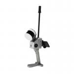
Geosun GFireEye Series GS-130G SLAM LiDAR HESAI XT32 Slam Algorithms Indoor Outdoor Mapping 3D Data Collection Geosun gFireEye Series GS-130G SLAM ...
2025-07-30 00:11:24
|
|
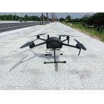
Multi Rotor LiDAR Drone Safety Aircraft Aerial Survey Operation Support GS-800 multi-rotor UAV aerial photographing and mapping system is made of high...
2025-07-25 11:55:21
|
|
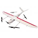
VTOL Fixed Wing Drone Application for Mapping & Survey GS-S300 is a pure electric VTOL fixed wing drone, with a simple and smooth appearance design, ...
2025-07-25 11:54:13
|

|
...GS-120G SLAM HESAI XT32 Slam Algorithms Indoor/Outdoor Mapping 3D Data Collection Geosun gFireEye Series GS-120G SLAM LiDAR GS-120G is a kind of ...
2025-07-30 00:11:24
|
|
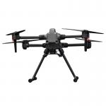
Multi-Rotor Drone Application for Mapping & Survey The GS-L400 is designed specifically for inspection, surveying, security, and wilderness rescue ...
2025-07-25 11:54:47
|

|
gCollector-M302 Road Information Collection LiDAR Scanning System The gCollector-M302 Road Information Collection system is a mobile real scense ...
2025-07-30 00:11:24
|

|
gCollector-M502 Road Information Collection LiDAR Scanning System The gCollector-M502 Road Information Collection system is a mobile real scense ...
2025-07-30 00:11:24
|

|
*, *::before, *::after {box-sizing: border-box; } * {margin: 0; } html, body {height: 100%; } body {line-height: 1.5; -webkit-font-smoothing: ...
2025-07-25 11:54:47
|