
Multi Rotor LiDAR Drone For Inspection Mapping Surveying Security
|
Detailed Product Description
|
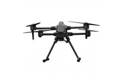
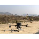
Multi-Rotor Drone Application for Mapping & Survey The GS-L400 is designed specifically for inspection, surveying, security, and wilderness rescue applications. The six-axis aircraft is designed to provide higher levels of safety, power, efficiency, and stability, with the ability to carry heavier payloads. Depending on the effective payload and weather conditions, the longest flight time can reach up to 65 minutes. The GS-L400 is equipped with dual IMUs, compass, barometer, dual RTK antennas, and two intelligent batteries, allowing for safe landing even if only five motors are running.
Technical Parameter
Application for Mapping & Survey
|
| Product Tags: Mapping Multi Rotor LiDAR Drone Surveying Multi Rotor LiDAR Drone Inspection LiDAR Drone |
Related Products

|
Terrain Mapping Aerial Surveying Geosun UAV LiDAR System GS-130X High Precision |

|
GS-100V UAV LiDAR System 360 Degree Fov Laser Sensor Colored Point Cloud Free Software |
|
AirPort Construction UAV LiDAR GS-260X High End Pos Built In RGB Camera |

|
GAirHawk Series GS-2000N LiDAR Scanning System Long Detection Airborne Mapping |
|
Geosun GAirHawk Series GS-260X UAV LiDAR Scanning System HESAI XTM2X Sensor |

|
Terrain Mapping GS-260X UAV LiDAR Scanning System HESAI Sensor |
Email to this supplier