
11 - 20 of 42
terrestrial lidar scanner 3d scanning
Selling leads

|
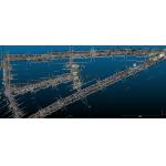
...3D Scanning for Long-Range Applications Product Introduction A fully independently developed long-range 3D laser scanner features a compact and ...
2025-07-29 13:58:19
|
|
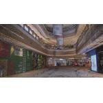
... clouds in the adjacent space quickly and easily in the environment without GNSS. The M10/M10+ LiDAR system offers exceptional detail with a ...
2025-07-29 13:58:20
|
|
M10/ M10+ With 360°rotate scanning mode and unique 3D SLAM algorithm technology, it can acquire high-precision and high-density 3D color point clouds ...
2025-07-29 13:58:14
|
|
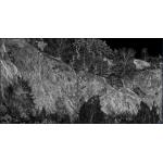
...capable of quickly capturing extensive surface 3D data. It ensures the acquisition of high-fidelity 3D laser point clouds, even in a variety of ...
2025-07-29 13:58:21
|

|
EasyScan M10/M10+ High Density Simplified Scanning Solution With 360°rotate scanning mode and unique 3D SLAM algorithm technology, it can acquire high...
2025-07-29 13:58:19
|

|
... metric camera. With the distributed structure first introduced in the industry and special accessories, it can be disassembled into 4 different ...
2025-07-29 13:58:09
|

|
...3D Scanning for Long-Range Applications Product Introduction EPiC EliteScan T1000: Powerful LiDAR For Extended Range And Accuracy A fully ...
2025-07-29 13:58:26
|
|
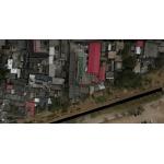
Easy Scan X10 / X10+ Versatile 3D laser Scanner Handheld SLAM and Airborne Drone LiDAR Multiple views from one The EasyScan X10/X10+ integrates ...
2025-07-29 13:58:23
|

|
Easy Scan X10 / X10+ Versatile 3D laser Scanner Handheld SLAM and Airborne Drone LiDAR Multiple views from one The EasyScan X10/X10+ integrates ...
2025-07-29 13:58:08
|

|
...capable of quickly capturing extensive surface 3D data. It ensures the acquisition of high-fidelity 3D laser point clouds, even in a variety of ...
2025-07-29 13:58:37
|