China 3D Laser Scanner manufacturer
Wuhan Eleph-Print Tech Co.,Ltd
The LiDAR Expert
2
Home > Products > Versatile Laser Scanner >

SLAM Handheld Aerial Precision 3D Scanning For Aerial And Mobile Mapping

Browse Categories

Wuhan Eleph-Print Tech Co.,Ltd

City: wuhan

Province/State:jiangxi

Country/Region:china

Tel:86-027-59902295

Contact Person:
Mr.Brandon Zhou
View Contact Details

SLAM Handheld Aerial Precision 3D Scanning For Aerial And Mobile Mapping

Brand Name EPiC LiDAR
Model Number EasyScan X10 / X10+
Certification CE, FCC
Place of Origin China
Minimum Order Quantity 1 set
Price Contact us
Payment Terms L/C, T/T
Supply Ability 100 sets per Month
Delivery Time 2 weeks
Packaging Details Tool Case
Brand EPiC LiDAR
Model X10 / X10+
Working Mode Handheld SLAM and Aerial
Dataset Contact us
Accuracy 5cm
Flying Height Suggest 80m-120m
Detailed Product Description
Easy Scan X10 / X10+ Versatile 3D laser Scanner Handheld SLAM and Airborne Drone LiDAR

Multiple views from one
 
The EasyScan X10/X10+ integrates cutting-edge LiDAR, GNSS, and high-precision IMU with an aerial metric camera for unparalleled accuracy in aerial and ground surveying. With its modular design, this system can switch between airborne, SLAM modes, ensuring optimal data capture in any scenario. Whether for UAV-based surveys or mobile scanning, it’s your one-stop solution for topographic mapping, smart grids, and civil engineering projects.


Equipped with dual scanning modes and advanced GNSS/IMU integration, the X10/X10+ provides accurate mapping for both UAV and handheld applications. Its lightweight build and high point frequency make it a reliable choice for complex, large-scale projects.

Products Introduction

 
Products Specification
 

ModelXI0XI0+


System

Parameter

Weight280g
DimensionL159*W118*H127(mm)
Average Power Consumption25W26W
Power Supply10~30V DC
Device InterfaceDJI Skyport/other interface available upon request
Data StorageUSB-disk 256GB
Operating Temperature-10℃~50℃
Storage Temperature-30℃~60℃
System Accuracy5cm
Compatible PlatformDJI M300 RTK/Other UAV models


Laser Unit

Scanning PrincipleMechanic Rotation Mirror
Laser ClassClassⅠ
Wavelength905nm
Measurement Range0.05m~120m@10%Reflectivity
Range Accuracy± 1cn
Horizontal FoV360°
Vertical FoV30°(-15~+15°)31°(-16~+15°)
Scanning Point FrequencySingle Return:320,000pts/s Dual Return:640,000pts/sSingle Return:640,000pts/s Dual Return:1,280,000pts/s
Return ModeSingle Return/Dual Return


GNSS&IMI

GNSS Signal TrackingBDS,GPS,GLONASS,GALILEO
Positioning Accuracy(post-processing)Plane:1cm/Elevation:2cm
Position Data Rate≥5HZ
Attitude Accuracy(post-processing)Heading:0.05°/pitch/roll:0.01°
Attitude Data Rate≥200HZ


Aerial Camera (External)

Effective Pixels26MP
Sensor Dimension23.5×15.7mm
Image Resolution6252×4168
Image Width FoV73°
GSD2.3cm@100m Flight Height


Slam Unit (Optional)

Weigh1051g(Battery not Included)
DimensionL136W149 H108(mm)
Scanning ModeFix Installed
Battery Duration4h for Single Battery
AccuracyRelative Accuracy 2cm/Absolute Accuracy 5cm


*The technical parameters and configuration of our products are subject to change without notice.


Notice:

① Weight includes LiDAR, GNSS,high-precision lMU, and aerial metric camera module②) Perpendicular to the flight direction, with the effective FoV angle of LiDAR③ Weight includes main body,SLAM dock, telescopic rod, and camera4) Tested at 25'c~ 27°C; charging time and power supply time will vary according to different conditions
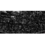
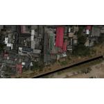
 

Feature

 
 High efficiency

Ultra-light aerial survey module, image acquisition not limited by LiDAR measurement range, flight height can be appropriately increased to improve the operation efficiency.

 
Not affected by light
LiDAR is not affected by the environment, has less side overlap, wider coverage of a single flight, and data can be easily collected even at night.
 
No signal limitation
Switch to SLAM mobile scanning mode, no limitation of GNSS signal, indoor and outdoor data integrated, collection makes the 3D data more complete
 
Real-time monitoring
Simultaneous acquisition of point cloud and orthophoto to achieve the real-time monitoring of flight trajectory, 3D point cloud, and images during the whole flight of the system.


Accessories

 
X10:
16 lines scanner *1
Camera *1
Skyport *1
Software dongle *1
Camera Adapter *1
GNSS receiver *1
X10+:
32 lines scanner *1
Camera *1
Skyport *1
Software dongle *1
Camera Adapter *1
GNSS receiver *1
SLAM handheld holder *1

Application


        Smart              Topographic         Emergency              Smart               Civil Defense      Pipeline
        Grid                  Mapping              Rescue                    Mining              Engineering        Inspection


Case

 
EasyScan X10+ is applied to measure the underground Parking Lot 


Sample Data Display
 
 
Product Tags: Aerial precision 3d scanning   Handheld precision 3d scanning   SLAM high precision 3d scanner  
Related Products
Email to this supplier
 
From:
Enter your Email please.
To: Wuhan Eleph-Print Tech Co.,Ltd
Subject:
Message:
Characters Remaining: (80/3000)