
1550nm 1400m Range Terrestrial Laser Scanner For Comprehensive Mapping
|


|
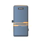
EliteScan T1000: High-Precision 3D Scanning for Long-Range Applications
Product Introduction
A fully independently developed long-range 3D laser scanner features a compact and portable design, capable of quickly capturing extensive surface 3D data. It ensures the acquisition of high-fidelity 3D laser point clouds, even in a variety of complex conditions.
Equipped with independent IP and SDK support, the T1000 offers exceptional accuracy and data quality for demanding applications. Its dual-axis tilt sensor and high scan speed make it a versatile solution for precise surface and structure inspections. Product Specification
Accessories
Features: Long Range Excellent ranging ability, max. measurement range up to 1400m.
High Accuracy Millimeter accuracy 5mm@100m, with more precision data details.
IIPR Developed with independent intellectual property rights, upgrade guaranteed
Easy Extension Supports customized integration and SDK.
Application: Polar Scientific Mine Monitoring BIM Industry Power Line Special Research Metrology Inspection Structure
Case
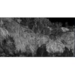
Sample Data Display
|
|||||||||||||||||||||||||||||||||||||||||||
| Product Tags: 1550nm Terrestrial Laser Scanner 1400m Terrestrial Laser Scanner Comprehensive Mapping terrestrial scanner |

|
High Precision 3D Terrestrial Laser Scanner Long Range 1000m |
|
Class I 3D Terrestrial Laser Scanner For Short Range High Precision |
|
High Precision 3D Scanning For Long Range Applications 1550nm Wavelength |

|
1550nm 1400m Range Terrestrial Laser Scanner For Comprehensive Mapping |

|
100m Measurement 3D Terrestrial Laser Scanner 905nm Wavelength |