
Class I 3D Terrestrial Laser Scanner For Short Range High Precision
|

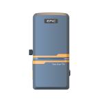
Terrestrial 3D Laser Scanner EPiC LiDAR EasyScan T05Product Introduction
The Easyscan T05, developed by EPiC Lidar, is an advanced terrestrial laser scanner designed for high-precision data capture. It features several enhancements that improve both usability and performance. With its lightweight, compact design, the T05 is highly portable and suitable for a variety of surveying tasks. It includes integrated sensors that allow for fast and accurate point cloud acquisition in true color, making it versatile across different environments. The scanner also boasts a user-friendly interface, simplifying operation and efficiently managing scanning tasks. This model is ideal for professionals in forestry, construction, and urban planning who need accurate and dependable 3D data.
Product Specification
Features:
High Integration
With three embedded high-definition cameras and one smart battery.
High Accuracy
5mm point cloud accuracy and pixel-level colorization.
Intelligent Workflow
One-click to collect data, it can calculate and splice data automatically.
Application:
Infrastructure Digital Underground BIM Mine Tank Management Plant Monitoring Calibration
Accessories
Case
EasyScan T05 Applied to BIM in Japan
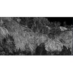
Sample Data Display
|
||||||||||||||||||||||||||||||||||||||||||||||
| Product Tags: Class I Terrestrial Laser Scanner Short Range Terrestrial Laser Scanner High Precision tls laser scanner |

|
High Precision 3D Terrestrial Laser Scanner Long Range 1000m |
|
Class I 3D Terrestrial Laser Scanner For Short Range High Precision |
|
High Precision 3D Scanning For Long Range Applications 1550nm Wavelength |

|
1550nm 1400m Range Terrestrial Laser Scanner For Comprehensive Mapping |

|
100m Measurement 3D Terrestrial Laser Scanner 905nm Wavelength |