
81 - 86 of 86
trajectory lidar scanner drone
Selling leads

|
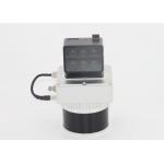
...LiDAR Scanning System 360 Degree Fov Laser Sensor Colored Point Cloud Free Software Geosun gAirHawk LiDAR Scanning System GS-100V gAirHawk GS-100V ...
2025-07-28 00:13:17
|
|
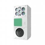
Compact Multispectral Camera LiDAR Scanning System For Forestry gAirHawk GS-130D is a kind of short-range, compact LiDAR point cloud data acquisition ...
2025-07-25 11:54:18
|
|
... LiDAR Scanning System with Integrated Multispectral Camera Geosun GS-100E LiDAR Scanning System Application for 3D Surveying and Mapping GS-100E ...
2025-07-25 11:54:19
|
|
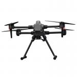
Multi-Rotor Drone Application for Mapping & Survey The GS-L400 is designed specifically for inspection, surveying, security, and wilderness rescue ...
2025-07-25 11:54:47
|
|
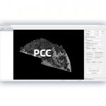
...LiDAR Data Pre-Processing Software with Built-in Trajectory and Point Cloud Calculation PointCloudCreater 2.0 is an advanced LiDAR data pre...
2025-07-25 11:56:05
|
|
... gAirHawk 5.0 is a powerful LiDAR data acquisition and pre-processing software independently developed by Geosun Navigation. Designed for use with ...
2025-07-25 11:56:11
|