
81 - 90 of 90
mapping uav lidar scanning system
Selling leads
|
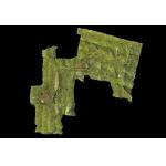
Forestry Surveying Drone LiDAR Geosun GS-260X Aerial Mapping Solution Geosun gAirHawk Series GS-260X Drone LiDAR Scanning System gAirHawk GS-260X is a ...
2025-07-31 00:16:27
|
|
Geosun GFireEye Series GS-130G SLAM LiDAR HESAI XT32 Slam Algorithms Indoor Outdoor Mapping 3D Data Collection Geosun gFireEye Series GS-130G SLAM ...
2025-07-31 00:16:27
|
|
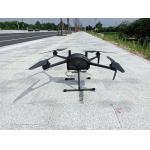
...LiDAR Drone Safety Aircraft Aerial Survey Operation Support GS-800 multi-rotor UAV aerial photographing and mapping system is made of high-strength ...
2025-07-25 11:55:21
|

|
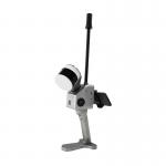
...GS-120G SLAM HESAI XT32 Slam Algorithms Indoor/Outdoor Mapping 3D Data Collection Geosun gFireEye Series GS-120G SLAM LiDAR GS-120G is a kind of ...
2025-07-31 00:16:27
|

|
gAirHawk GS-100M+ LIDAR SCANNING SYSTEM LiDAR Scanning System with 3D Data Livox Avia Laser Sensor gAirHawk GS-100M+ is a kind of light compact LiDAR ...
2025-07-31 00:16:27
|

|
gAirHawk GS-260P LIDAR SCANNING SYSTEM Drone LiDAR Scanning System Mounted on DJI Drone with Triple Echo Livox Avia Laser Sensor gAirHawk GS-260P is a ...
2025-07-31 00:16:27
|
|
gAirHawk GS-260P LIDAR SCANNING SYSTEM Drone LiDAR Scanning System mounted on DJI M300 with 3D data collection gAirHawk GS-260P is a kind of light ...
2025-07-31 00:16:27
|

|
gAirHawk GS-130H Mobile LIDAR SCANNING SYSTEM Mobile LiDAR Scanning System Application for Autonomous Driving gAirHawk GS-130H New Designed is a kind ...
2025-07-31 00:16:27
|

|
gCollector-M302 Road Information Collection LiDAR Scanning System The gCollector-M302 Road Information Collection system is a mobile real scense ...
2025-07-31 00:16:27
|

|
gCollector-M502 Road Information Collection LiDAR Scanning System The gCollector-M502 Road Information Collection system is a mobile real scense ...
2025-07-31 00:16:27
|