
101 - 103 of 103
lidar mapping 3d scanning
Selling leads

|
*, *::before, *::after {box-sizing: border-box; } * {margin: 0; } html, body {height: 100%; } body {line-height: 1.5; -webkit-font-smoothing: ...
2025-07-25 11:54:47
|
|
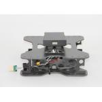
Mounting Kits for DJI M210, M300, M600 Pro and other brands. DJI drones are good application for survey & mapping, especially for DJI M210, M300 and ...
2025-07-25 11:53:58
|
|
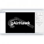
... gAirHawk 5.0 is a powerful LiDAR data acquisition and pre-processing software independently developed by Geosun Navigation. Designed for use with ...
2025-07-25 11:56:11
|