
11 - 20 of 87
geosun drone mounted lidar
Selling leads
|
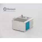
gAirHawk GS-260F UAV LIDAR SCANNING SYSTEM Drone LiDAR Scanning System Application for Mapping and Survey with DJI Drone gAirHawk GS-260F is a kind of ...
2025-07-28 00:13:17
|
|
gAirHawk GS-260F UAV LIDAR SCANNING SYSTEM Drone LiDAR Scanning System Application for Mapping and Survey GS 260F Mobile LiDAR System - YouTube ...
2025-07-28 00:13:17
|
|
Drone Lidar Scanner Geosun GS-130X 3D Scanning Built-In RGB Camera Total Aerial Solution DJI M300 Cost Effective Application of UAV LiDAR Scanning ...
2025-07-28 00:13:17
|

|
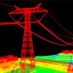
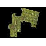
...Drone LiDAR Scanning System Geosun GS-130X Colored Point Cloud High Accuracy Geosun gAirHawk Series GS-130X Drone LiDAR Scanning System Drone LiDAR ...
2025-07-28 00:13:17
|
|
...Drone LiDAR Scanning System Geosun GS-260X PPK RTK Processing Geosun gAirHawk Series GS-260X Drone LiDAR Scanning System Drone LiDAR Scanning ...
2025-07-28 00:13:17
|
|
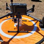
...LiDAR System Geosun gAirHawk GS 130H DJI M600 Pro Livox Horizon LiDAR Drone LiDAR Scanning System Mounted on DJI M600 Pro , Forestry Application ...
2025-07-28 00:13:17
|

|
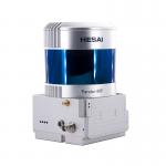
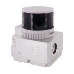
2.1kg 20W HESAI Pandar 40P airborne 3D Mapping Drone LiDAR Geosun GS-260F Geosun gAirHawk Series GS-260F Drone LiDAR Scanning System gAirHawk GS-260F ...
2025-07-28 00:13:17
|
|
Forestry Surveying Drone LiDAR Geosun GS-260X Aerial Mapping Solution Geosun gAirHawk Series GS-260X Drone LiDAR Scanning System gAirHawk GS-260X is a ...
2025-07-28 00:13:17
|
|
...Drone LiDAR Mapping 3D Scanning Accuractely Capture Demonstration In Australia Geosun gAirHawk Series Drone LiDAR Scanning System GS-130X Drone ...
2025-07-28 00:13:17
|
|
Geosun GS-260H UAV LiDAR Aerial Mapping Drone Surveying City Construction 3D Modeling Geosun gAirHawk LiDAR Scanning System GS-260H gAirHawk GS-260X ...
2025-07-28 00:13:17
|