
21 - 27 of 27
aerial surveying uav lidar system
Selling leads
|
Geosun GS-260H UAV LiDAR Aerial Mapping Drone Surveying City Construction 3D Modeling Geosun gAirHawk LiDAR Scanning System GS-260H gAirHawk GS-260X ...
2025-07-28 00:13:17
|
|
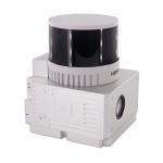
Land Mapping Drone Payload UAV LiDAR Surveying Geosun Partner In Indian Multi-Rotor Support High Precision Geosun gAirHawk Series GS-260X uav LiDAR ...
2025-07-28 00:13:17
|
|
Drone Lidar Scanner Geosun GS-130X 3D Scanning Built-In RGB Camera Total Aerial Solution DJI M300 Cost Effective Application of UAV LiDAR Scanning ...
2025-07-28 00:13:17
|
|
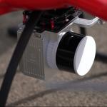
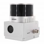
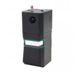
Drone Surveying HESAI Pandar40p Laser Scanner Geosun GS-260F UAV LiDAR Scanning System LiDAR Scanning System with HESAI Pandar Laser Sensor Mounted on ...
2025-07-28 00:13:17
|
|
...UAV LiDAR scanning system developed by Geosun Navigation. Its integrated design combines surveying-grade LiDAR, a high-performance IMU, and ...
2025-07-25 11:55:03
|
|
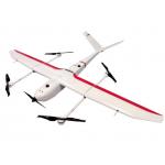
...Survey GS-S300 is a pure electric VTOL fixed wing drone, with a simple and smooth appearance design, which enables the drone to cruise at a speed ...
2025-07-25 11:54:13
|
|
gAirHawk GS-260F UAV LIDAR SCANNING SYSTEM Drone LiDAR Scanning System Application for Mapping and Survey GS 260F Mobile LiDAR System - YouTube ...
2025-07-28 00:13:17
|