
51 - 60 of 95
750g 3d mapping lidar
Selling leads

|
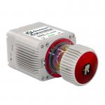
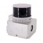
Geosun GAirHawk Series GS-1500N LiDAR Scanning System 8 Echos Long Detection Aerial VTOL Mapping High Accuracy Geosun gAirHawk Series GS-1500N LiDAR ...
2025-07-28 00:13:17
|
|
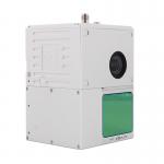
...LiDAR Scanning System High Accuracy Colored Point Cloud Long Detection Airborne Mapping Geosun gAirHawk Series GS-2000R LiDAR Scanning System The ...
2025-07-25 11:55:05
|
|
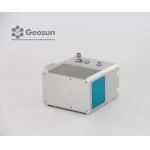
...LiDAR Scanning System For Forestry gAirHawk GS-130D is a kind of short-range, compact LiDAR point cloud data acquisition system, integrated HESAI ...
2025-07-25 11:54:18
|
|
gCollector-M302 Road Information Collection LiDAR Scanning System The gCollector-M302 Road Information Collection system is a mobile real scense ...
2025-07-28 00:13:17
|
|
gCollector-M502 Road Information Collection LiDAR Scanning System The gCollector-M502 Road Information Collection system is a mobile real scense ...
2025-07-28 00:13:17
|
|
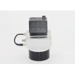
DJI M600 Pro 32 Channel HESAI Pandar Laser UAV LiDAR Scanning System GS-260X Forestry Geosun gAirHawk Series GS-260X uav LiDAR Scanning System ...
2025-07-28 00:13:17
|
|
... gAirHawk GS-100C+ is a kind of light compact LiDAR point cloud data acquisition system, integrated Livox new generation laser scanner, GNSS and ...
2025-07-28 00:13:17
|

|
Aerial Mapping GS-100V UAV LiDAR Scanning System 360 Degree Fov Laser Sensor Colored Point Cloud Free Software Geosun gAirHawk LiDAR Scanning System ...
2025-07-28 00:13:17
|
|
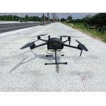
UAV LiDAR System Geosun gAirHawk GS 130H DJI M600 Pro Livox Horizon LiDAR Drone LiDAR Scanning System Mounted on DJI M600 Pro , Forestry Application ...
2025-07-28 00:13:17
|
|
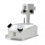
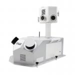
...LiDAR Drone Safety Aircraft Aerial Survey Operation Support GS-800 multi-rotor UAV aerial photographing and mapping system is made of high-strength ...
2025-07-25 11:55:21
|