China LiDAR Scanning System manufacturer
Wuhan Geosun Navigation Technology Co., Ltd.
Geosun's Wishes and Aspirations: Make the LiDAR/SLAM Solution More Applicable and Affordable
5
Home > Products > Trajectory Processing Software >

GGPoS Software – High-Precision GNSS Positioning and Velocity Solution

Browse Categories

Wuhan Geosun Navigation Technology Co., Ltd.

City: wuhan

Province/State:hubei

Country/Region:china

Tel:+86--15527360208

Contact Person:
Mr.Lanbooxie
View Contact Details

GGPoS Software – High-Precision GNSS Positioning and Velocity Solution

Brand Name Geosun
Model Number GnssExplorer
Certification Intellectual Property Right
Place of Origin China
Minimum Order Quantity 1
Price Negotiation
Payment Terms T/T, Western Union
Supply Ability No limitation
Delivery Time 1-3 Working Days Since Payment
Packaging Details None
Application 1 Aerial Mapping
Application 2 PPK solution
Function Positioning
Precision less than 5 cm
Feature Self-Developed
Origin China
Detailed Product Description

GGPoS Software – High-Precision GNSS Positioning and Velocity Solution


GGPoS is a high-precision GNSS data processing software system designed for GPS, GLONASS, BeiDou, and Galileo constellations. It supports both single-frequency and dual-frequency signals, delivering centimeter-level positioning accuracy and millimeter-per-second velocity measurement in real-time through carrier phase data processing.


Key Technologies and Advantages

  • Advanced Single-Epoch Ambiguity Resolution
    GGPoS adopts a globally leading proprietary algorithm that effectively eliminates the need for traditional initialization steps, ensuring immediate high-precision results even in dynamic or obstructed environments.

  • Robust and Accurate Performance
    With a combination of core technologies in satellite signal processing and data fusion, GGPoS delivers stable and reliable outputs across diverse operational scenarios.

  • Modular and Scalable Architecture
    Developed with a modular design, GGPoS can be easily extended and customized to meet different industry needs and application requirements.


Application Fields

GGPoS is widely applicable in various high-precision engineering and industrial sectors, including:

  • Land surveying and mapping

  • Intelligent transportation systems

  • Water conservancy and hydrology

  • Electric power infrastructure

  • Maritime operations

  • Railway networks

  • Oil and gas pipelines

  • Aviation and aerospace platforms


Free Software for Testing-Document Overview:Trial Software Information

Click here to watch the video:Positioning Altitude Aerial Photogrammetry Trajectory Process Software


PPK Process


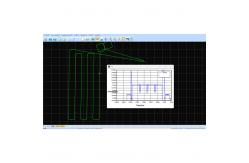
Select the Satellites and GNSS Date Decode (the .kqs file to .20o file)


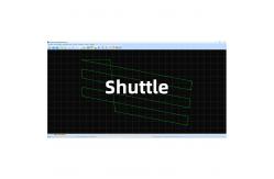
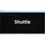
The GNSS results from Shuttle (kinematic Differencial GNSS)


GNSS Result

Product Tags: High Accuracy GNSS Positioning System   High Accuracy Velocity Determination System   Trajectory GNSS System  
Related Products
Email to this supplier
 
From:
Enter your Email please.
To: Wuhan Geosun Navigation Technology Co., Ltd.
Subject:
Message:
Characters Remaining: (80/3000)