
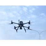
High Accuracy UAV Aerial LiDAR System EliteScan W50
|


|
Product Introduction
W50 is designed as a highly integrated airborne LiDAR system and its core parts are fully developed by EPiC LiDAR, including high-performance LiDAR, IMU, and aerial camera. It features a long scanning range, lightweight, strong penetration, and higher working efficiency than ever, which can deal with the most challenging and complex scenarios.
Products Specification
Features Light Weight Highly integrated with an overall weight of 1.4kg only
Long Range Typical flying height up to 400m.
Strong Penetration With 7 echo returns, it can penetrate into vegetation to acquire ground points easily.
High Efficiency Wider FoV and higher working efficiency.
Application
Topographic Electricity Disaster Mining Nature Resource Mapping Inspection Survey Mapping Investigation
Case
Sample Data Display
|
|||||||||||||||||||||||||||||||||||||||||||||||||||||||||||||||||||||||||||||||||||||||||||||||||||
| Product Tags: High Accuracy aerial lidar system UAV aerial lidar system EliteScan lidar scanning equipment | |||||||||||||||||||||||||||||||||||||||||||||||||||||||||||||||||||||||||||||||||||||||||||||||||||

|
80m-120m Easyscan X10 Versatile 3D Laser Scanner For Volume Measurement |

|
Aerial 3D Laser Scanning System For Real 3D And Smart Mining |
|
High Accuracy UAV Aerial LiDAR System EliteScan W50 |

|
EasyScan W30 Airborne LiDAR For Enhanced Aerial Efficiency 905nm Wavelength |

|
Precision Airborne Laser Scanning In Aerial LiDAR Easyscan W30 |

|
W50 LiDAR System Compact Powerful Mapping Tool Compatible To DJI M300 M350 |