
Aerial 3D Laser Scanning System For Real 3D And Smart Mining
|


|
Aerial 3D Laser Scanning System For Real 3D And Smart Mining Product Introduction
Features Ultra long endurance the innovative design of the system makes the whole scanner smaller in size and only 960g in weight, which can effectively extend the flight time in the air.
Ultra-high precision with the unique intelligent algorithm, the massive 3D point cloud obtained can achieve professional-level measurement accuracy.
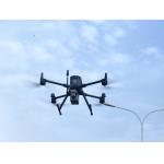
Extremely integrated seamless compatible with DJI M300 RTK, the system is designed for unprofessional users, through simple plug and play, the user can control and monitor the whole system by using integrated Apps in DJI’s control unit; the data is well organized to be stored, with a simple one -click, the data can be downloaded locally.
Real-time monitoring transmitted back and displayed in DJI’s control unit in order to help the user to evaluate the system in the air in real time. Applications
Accessories Case Sample Data Display
|
||||||||||||||||||||||||||||||||||||||||||||||||||||||||||||||
| Product Tags: Aerial 3d laser scanning system Smart Mining 3d laser scanning system 905nm 3d scanner system |

|
80m-120m Easyscan X10 Versatile 3D Laser Scanner For Volume Measurement |

|
Aerial 3D Laser Scanning System For Real 3D And Smart Mining |
|
High Accuracy UAV Aerial LiDAR System EliteScan W50 |

|
EasyScan W30 Airborne LiDAR For Enhanced Aerial Efficiency 905nm Wavelength |

|
Precision Airborne Laser Scanning In Aerial LiDAR Easyscan W30 |

|
W50 LiDAR System Compact Powerful Mapping Tool Compatible To DJI M300 M350 |