
41 - 50 of 58
terrain mapping uav lidar system
Selling leads
|
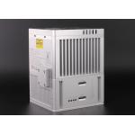
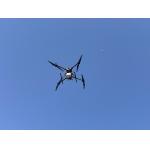
gAirHawk GS-300T LIDAR SCANNING SYSTEM Drone LiDAR Scanning System Mounted on VTOL Fixed wing drone gAirHawk GS-300T is a kind of Mid-range, compact ...
2025-07-28 00:13:17
|
|
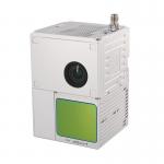
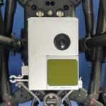
gAirHawk GS-100C+ LIDAR SCANNING SYSTEM Mobile LiDAR Scanning System Mounted on Vehicle Integrated DJI L1 Laser Sensor and Build-in Camera gAirHawk GS...
2025-07-28 00:13:17
|
|
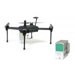
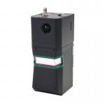
gAirHawk GS-100M+ LIDAR SCANNING SYSTEM Mobile LiDAR Scanning System with DJI L1 Laser Sensor gAirHawk GS-100M+ is a kind of light compact LiDAR point ...
2025-07-28 00:13:17
|

|
*, *::before, *::after {box-sizing: border-box; } * {margin: 0; } html, body {height: 100%; } body {line-height: 1.5; -webkit-font-smoothing: ...
2025-07-25 11:54:47
|
|
...LiDAR System Geosun GS-100C+ Aerial Mapping Survey High Precision IMU Coloured Point Cloud Geosun Thailand partner have a on-site trainning at ...
2025-07-28 00:13:17
|
|
...UAV LiDAR scanning system developed by Geosun Navigation. Its integrated design combines surveying-grade LiDAR, a high-performance IMU, and ...
2025-07-25 11:55:03
|
|
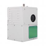
Geosun Drone LiDAR GS-100C+ Support DJI Matrice 300 Yuneec H850 Aerial Mapping Geosun gAirHawk Series GS-100C+ Drone LiDAR Drone LiDAR scanning system ...
2025-07-28 00:13:17
|

|
...Mapping for Mine Drone LiDAR Scanning System Geosun GS-130X Colored Point Cloud High Accuracy Geosun gAirHawk Series GS-130X Drone LiDAR Scanning ...
2025-07-28 00:13:17
|
|
gAirHawk GS-260F UAV LIDAR SCANNING SYSTEM Drone LiDAR Scanning System Application for Mapping and Survey GS 260F Mobile LiDAR System - YouTube ...
2025-07-28 00:13:17
|

|
... System gAirHawk GS-2000N is a kind of long range, compact LiDAR point cloud data acquisition system, integrated FT-1500H long range laser scanner, ...
2025-07-28 00:13:17
|