
91 - 96 of 96
terrain mapping uav lidar
Selling leads

|
gCollector-M302 Road Information Collection LiDAR Scanning System The gCollector-M302 Road Information Collection system is a mobile real scense ...
2025-07-29 00:11:05
|

|
gCollector-M502 Road Information Collection LiDAR Scanning System The gCollector-M502 Road Information Collection system is a mobile real scense ...
2025-07-29 00:11:05
|
|
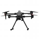
Multi-Rotor Drone Application for Mapping & Survey The GS-L400 is designed specifically for inspection, surveying, security, and wilderness rescue ...
2025-07-25 11:54:47
|
|
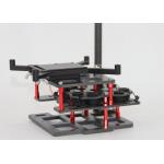
Mounting Kits for DJI M210, M350/300, M600 Pro and other brands. DJI drones are good application for survey & mapping, especially for DJI M210, M300 ...
2025-07-25 11:53:58
|
|
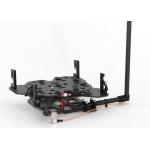
Mounting Kits for DJI M210, M300, M600 Pro and other brands. DJI drones are good application for survey & mapping, especially for DJI M210, M300 and ...
2025-07-25 11:53:59
|
|
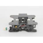
Mounting Kits for DJI M210, M300, M600 Pro and other brands. DJI drones are good application for survey & mapping, especially for DJI M210, M300 and ...
2025-07-25 11:53:58
|