
11 - 20 of 24
surveying multi rotor lidar drone
Selling leads
|
...Drone LiDAR Scanning System Geosun GS-260X PPK RTK Processing Geosun gAirHawk Series GS-260X Drone LiDAR Scanning System Drone LiDAR Scanning ...
2025-07-30 00:11:24
|
|
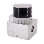
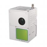
Drone Surveying HESAI Pandar40p Laser Scanner Geosun GS-260F UAV LiDAR Scanning System LiDAR Scanning System with HESAI Pandar Laser Sensor Mounted on ...
2025-07-30 00:11:24
|
|
... LiDAR point cloud data acquisition system, integrated HESAI XT laser scanner, GNSS and IMU positioning and attitude determination system, and ...
2025-07-25 11:54:18
|
|
Fixed Wing Drone UAV LiDAR GS-130X HESAI XT32 3D Mapping Strong Penetration Geosun gAirHawk Sesries GS-130X uav LiDAR Scanning System LiDAR Scanning ...
2025-07-30 00:11:24
|
|
gAirHawk GS-260P LIDAR SCANNING SYSTEM Drone LiDAR Scanning System mounted on DJI M600 Pro Application for Terrain Survey gAirHawk GS-260P is a kind ...
2025-07-30 00:11:24
|
|
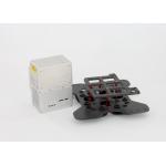
Mounting Kits for DJI M210, M350/300, M600 Pro and other brands. DJI drones are good application for survey & mapping, especially for DJI M210, M300 ...
2025-07-25 11:53:58
|
|
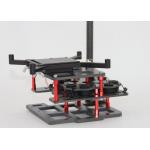
Mounting Kits for DJI M210, M300, M600 Pro and other brands. DJI drones are good application for survey & mapping, especially for DJI M210, M300 and ...
2025-07-25 11:53:59
|
|
Geosun GS-260H UAV LiDAR Aerial Mapping Drone Surveying City Construction 3D Modeling Geosun gAirHawk LiDAR Scanning System GS-260H gAirHawk GS-260X ...
2025-07-30 00:11:24
|
|
gAirHawk GS-100C+ LIDAR SCANNING SYSTEM Drone LiDAR Scanning System Mounted on DJI M600 Pro Application for Mapping and Survey gAirHawk GS-100C+ is a ...
2025-07-30 00:11:24
|
|
GS-260F RTK Model Drone LiDAR Scanner HESAI Pandar40P Multi Platform Free Trajectory Processing Geosun gAirHawk Series Drone LiDAR Scanning System GS...
2025-07-25 11:55:45
|