
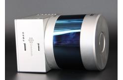
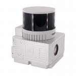
HESAI Pandar 20B Topographic Mapping UAV LiDAR System
|
Detailed Product Description
|
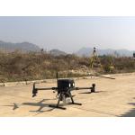
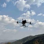
gAirHawk GS-260S UAV LIDAR SCANNING SYSTEM Drone LiDAR Scanning System mounted on DJI M300 Application for Topographic Mapping gAirHawk GS-260S is a kind of Mid-range, compact LiDAR point cloud data acquisition system, integrated HESAI Pandar 40P laser scanner, GNSS and IMU positioning and attitude determination system, and storage control unit, is able to real-time, dynamically, massively collect high-precision point cloud data and rich image information. It is widely used in the acquisition of 3D spatial information in surveying, electricity, forestry, agriculture, land planning.
Pandar20B 20-Channel Mechanical LiDAR
Specification
Application for Forestry
Package
|
|||||||||||||||||||||||||||||||||||||||||||||||||||||||||||||||||||||
| Product Tags: Topographic Mapping 20 Beam UAV LiDAR HESAI Pandar 20B UAV LiDAR System 20 Beam DJI M300 LiDAR | |||||||||||||||||||||||||||||||||||||||||||||||||||||||||||||||||||||
Related Products

|
Terrain Mapping Aerial Surveying Geosun UAV LiDAR System GS-130X High Precision |

|
GS-100V UAV LiDAR System 360 Degree Fov Laser Sensor Colored Point Cloud Free Software |
|
AirPort Construction UAV LiDAR GS-260X High End Pos Built In RGB Camera |

|
GAirHawk Series GS-2000N LiDAR Scanning System Long Detection Airborne Mapping |
|
Geosun GAirHawk Series GS-260X UAV LiDAR Scanning System HESAI XTM2X Sensor |
|
Terrain Mapping GS-260X UAV LiDAR Scanning System HESAI Sensor |
Email to this supplier