
21 - 30 of 242
geophysical exploration digital inclinometer
Selling leads

|
Resisitvity Tomography Geophysical Exploration Instrument ERT Survey Main Functions The resistivity tomography geophysical exploration instrument can ...
2024-12-09 22:21:14
|
|
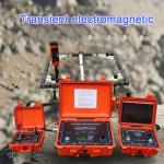
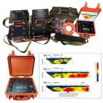
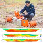
WTEM Transient ElectroMagnetic Instrument for shallow surface geophysical exploration and survey Transient Electromagnetic Method (TEM) is a ...
2024-12-10 00:43:17
|
|
Geophysical DC Digital IP&Resistivity Meter Surface Electrical Resistivity Testing Device for Gold Mineral Underwater Detection The WDDS-2C/3C digital ...
2025-11-26 00:17:28
|
|
... measurement cable allows scanning of large targets up to 30 meters in depth over a 1000 m2 area. An important feature of the adrenalin geophysical ...
2025-11-26 00:17:28
|
|
... sounding method. Its principle is the same as that of ordinary resistivity method. The difference is that high-density observation points are set ...
2024-12-09 22:21:14
|
|
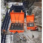
Digital Transformation for Surveys: WGMD-4's Smart Geological Platform Connecting Traditional Surveys to Digital Future Smart homes automate daily ...
2025-11-26 00:17:28
|
|
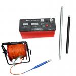
Geophysical Drilling Well Inclinometer Borehole Logging Survey Tool Inclinometer depth ≤1500 m Measuring range and error Angle measuring range 0 ~ 50 ...
2025-11-26 00:17:28
|
|
Geophysical Exploration Instrument Electrical Resistivity Imaging Meter Introduction 2D Resistivity Imaging uses an array of electrodes (typically 60/ ...
2025-11-26 00:17:28
|

|
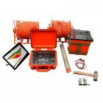
2D Resistivity IP Geophysical Exploration Instrument Tomography Survey Introduction WGMD-9 super multi-electrode electrical tomography system is a new ...
2025-11-26 00:17:28
|
|
2/3D Resistivity&IP imaging instrument geophysical exploration for underground Maximum transmitting powe 7200W Maximum supply voltage 1200V (with WDZJ...
2024-12-09 23:37:26
|