
Saltwater Intrusion Monitoring Equipment Contamination Plume Mapping System
|

|
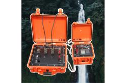
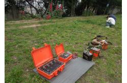
Protecting the Nation's Critical Assets: WGMD-4 for Defense and Security Infrastructure The infrastructure of national defense—military bases, naval shipyards, airfields, missile silos, secure communication facilities, and border security installations—represents a category of asset where failure is not measured in dollars, but in compromised national security and lost lives. These facilities must operate under extreme conditions, resist deliberate attack, and maintain functionality when the nation needs them most. The WGMD-4 Defense Infrastructure Intelligence System is engineered to the exacting standards required for these critical assets. It provides ±1% absolute accuracy in characterizing the geotechnical and geoenvironmental conditions that underpin their resilience, while wielding 900V of deep-interrogation power to detect hidden threats and vulnerabilities. It serves as the definitive tool for military engineers, security planners, and defense contractors tasked with ensuring that the nation's most sensitive and vital installations are founded on rock-solid, fully understood ground. Bunker and Hardened Facility Siting: The Ultimate Foundation
Requirement Five Critical Defense and Security Applications Naval Shipyard and Submarine Base Geotechnical Integrity: Shipyards handling the largest vessels of the fleet require massive dry docks, crane rails, and heavy-lift pads. Differential settlement can render a dry dock unusable or misalign critical rail systems. The WGMD-4 provides the continuous geotechnical model for these facilities, identifying zones requiring deep foundation support and ensuring that all load-bearing structures are founded on ground that will not settle differentially. This protects the nation's ability to maintain, repair, and deploy its naval assets. Secure Communication Facility Site Selection and Monitoring: The nation's strategic communications and command-and-control facilities require absolute stability and security. The WGMD-4 assists in site selection by identifying locations with low natural background noise (important for sensitive receiving stations) and with geology that is resistant to tunneling or other subsurface intrusion. For existing facilities, it can be deployed for periodic security scans, detecting any unauthorized subsurface activity, such as the digging of a tunnel, that could compromise the facility. Missile Silo and Launch Complex Foundation Verification: Intercontinental ballistic missile silos represent the ultimate in hardened infrastructure, designed to withstand near-miss nuclear effects. The WGMD-4 is used during construction verification to ensure that the ground surrounding the silo liner meets the precise, uniform bearing capacity specifications required for the structure to survive extreme ground shock. Post-construction, it can be used for long-term monitoring to detect any changes in ground properties that could affect performance. Border Security Infrastructure Assessment: Border walls, vehicle barriers, and surveillance towers are only as effective as their foundations. The WGMD-4 provides the geotechnical data needed to design these structures to withstand undermining, scour, or deliberate breaching attempts. It can also be used to map potential smuggling tunnels or detect voids beneath barriers, providing border security agencies with actionable intelligence to close these vulnerabilities. Defense Infrastructure Specifications Table
The National Security Imperative: Knowledge is Protection |
||||||||||||||
| Product Tags: saltwater intrusion monitoring equipment contamination plume mapping system geophysical exploration instrument with warranty |

|
Drillhole Structural Mapping Tool Subsurface Drillhole Imager |

|
Earthquake Fault Magnetotellurometer Infrastructure Site Magnetotellurometer |

|
Grout Seal Integrity Viewer Packer Setting Confirmation Cam |

|
Grout Seal Integrity Viewer Packer Setting Confirmation Cam |
|
Seismic Source Technology Advanced Seismic Source |

|
Contaminant Plume Imaging Tool Bridge Foundation Survey Meter |