
Multi-purpose Geophysical Tool for Mineral & Civil Engineering Prospecting
|



|
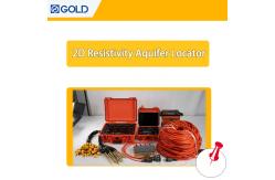
Multi-purpose Geophysical Tool for Mineral & Civil Engineering Prospecting A versatile geophysical tool for simultaneous Res and IP surveys, it’s ideal for metal/non-metal mineral exploration and civil geophysical exploration. The transmitter part offers a maximum power of 6600W for general Res/IP sounding. It weighs ≤4.4 kg for easy transport. Product Description The WDJD - 4A is a cutting - edge geophysical exploration instrument that revolutionizes subsurface investigation. It enables simultaneous Resistivity (Res) and Induced Polarization (IP) surveys with a perfect combination of high accuracy, fast speed, high reliability, and outstanding expandability. This versatile instrument is widely utilized in various fields. In the realm of mineral resources, it plays a crucial role in both metal and non - metal mineral exploration, helping to pinpoint potential ore bodies. For civil engineering, it supports geophysical exploration for infrastructure projects like rail - way/bridge prospecting to assess subsurface conditions. Moreover, it is highly effective in groundwater detection, locating hidden dangers in dam foundations and flood - control dykes, as well as for hydrological, engineering, and geothermal prospecting. Whether you are searching for valuable minerals, ensuring the safety of civil engineering structures, or exploring groundwater resources, the WDJD - 4A provides accurate and reliable data to drive informed decision - making.
Unify your geophysical data with comprehensive intelligence integration. Our platform combines multiple data streams into actionable insights through advanced processing and visualization tools. Integration capabilities:
Data Integration Matrix:
Achieve complete data unity with our integrated intelligence platform.
FAQ
|
||||||||||||||||||||
| Product Tags: geophysical prospecting tool for mineral exploration civil engineering geophysical instrument multi-purpose geophysical exploration tool |

|
Drillhole Structural Mapping Tool Subsurface Drillhole Imager |

|
Earthquake Fault Magnetotellurometer Infrastructure Site Magnetotellurometer |

|
Grout Seal Integrity Viewer Packer Setting Confirmation Cam |

|
Grout Seal Integrity Viewer Packer Setting Confirmation Cam |
|
Seismic Source Technology Advanced Seismic Source |

|
Contaminant Plume Imaging Tool Bridge Foundation Survey Meter |