
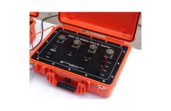
2D 3D Multi Channel Geophysical Resistivity Meter Survey Instrument
|
|
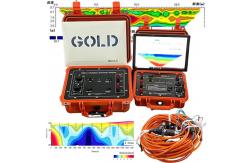
2D 3D Multi Channel Geophysics Survey Instrument Geophysical Resistivity Meter
How to interpret 2D 3D Geophysical Electrical Resistivity Meter Survey Data?
Under suitable method,mutil-electrode 2D 3D Geophysical Electrical Resistivity Meter is the apparent electrical resistivity imaging . High-resistance area represents compact rock mass with good integrity and low water content; Low-resistance zone represents water-bearing, loose broken or fractured water-bearing zone of rock mass. Karst cavities show high resistance area, and karst caves filled with clay and water show low resistance area. Most karst caves and karst fracture zones are partially filled, the upper part is hollow, the lower part is loose filled, the upper part is high resistance, and the lower part is low resistance, forming intermittent beaded combined abnormal areas. To sum up, the karst interpretation and determination of electrical resistivity images follow the following three principles: ① the upper part of the karst zone is a cavity, and the lower part is a filling, showing a beaded anomaly of intermittent combination of high resistance and low resistance; ② Karst is developed in limestone, and the background resistivity value has high resistivity characteristics; ③ Karst is developed along the structural fracture zone, and the trend and occurrence of beaded anomaly are consistent with the regional structure. The resistivity anomaly image conforming to the above three principles is interpreted as karst. Some karst is completely filled, and there is no overhead cave, especially the karst buried below the groundwater level, which is completely filled with loose matter and water, showing strong low resistance characteristics.
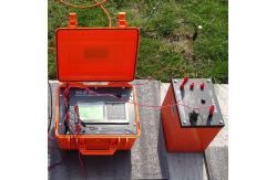
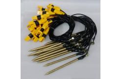
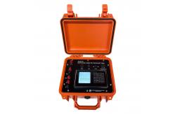
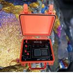
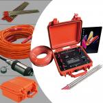
Please see as following details about our geophysical electrical resistivity meter:
Technical specification
Certificate
Shipping and Delivery
Customer services 1. We provide one-year warranty, during this period, we are responsible for any mechanical failures or faults caused by design technology or material and handle any improper errors for free; we will still provide free technical assistance beyond this period (only charge parts' cost price and traveling allowance). 2. If there are any failures because of our products' quality in use, we will provide the phone instructions within 2 hours to help solving the problems, and we will supply on-line video technical communication if necessary. 3. We can dispatch the experienced engineer for installation and debugging after receiving the customer's notification. 4. We will provide free training, installation, debugging service in China, it is also available to send professional staff overseas for installation and debugging, only the traveling costs and labor costs will be borne by you. 5. After sale, we provide regular phone service to collect the customer's suggestions and advice.
|
||||||||||||||||||||||||||||||||||||||||||||||||||||||||
| Product Tags: 3D Geophysical Resistivity Meter Multi Channel Geophysical Resistivity Meter Multi Channel Resistivity Meter | ||||||||||||||||||||||||||||||||||||||||||||||||||||||||

|
Light Weight ≤4.2Kg Geophysical Resistivity Meter with Methodological Flexibility and Research-Grade Data Transparency |

|
Karst Cavity Detection System Environmental Site Investigation Tool Subsurface Contamination Detector |

|
Field-Deployable High Precision Geophysical Resistivity Meter with Educational Resource Package |
|
Geophysical Resistivity Meter with Depth Range 0~1000 meters Compact Size 270mm×246mm×175mm and Max Voltage 1000V |
|
WDJD-4A Geophysical Resistivity Meter with 0-500m Prospecting Depth and Multi-electrode 2D Resistivity Imaging for High Accuracy Surveys |
|
Digital DC exciter & Underground Geophysical Resistivity Meter For Gold Finder |