
Custom 2D Electrical Resistivity Tomography / Geophysical Resistivity System
|
|
2D Electrical Resistivity Tomography Geophysical Resistivity System
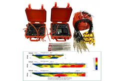
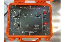
The mutil-electrode geophysical resistivity system used an array exploration method, also known as the automatic resistivity system. It is the development of the direct current method, which is equivalent to the combination of 4 poles vertical electrical sounding and electrical profile method. The artificial electric field is formed by electrode power supply to the underground, and the distribution of the electric field is closely related to the distribution of the resistivity of the underground geotechnical medium. By measuring the artificial electric field of different parts of the surface, the distribution of the visual resistivity of the underground medium is understood, and the underground geological structure is inferred and explained according to the distribution of the visual resistivity of the geotechnical medium. 2D Electrical Resistivity Tomography is particularly sensitive to the water content of surrounding rock. If the surrounding rock is broken, the apparent resistivity is significantly reduced, and the visual resistivity of complete and hard rock and soil is significantly higher than that of fault zone or fracture zone and water-rich zone. This method has clear principle and intuitive image, and is a geophysical exploration method with high resolution. In recent years, with the improvement of computer data acquisition technology, the exploration efficiency has been greatly improved, the coverage area and detection depth of the section have been increased, the reliable data can be obtained in the environment of strong interference, the signal-to-noise ratio has been greatly improved, and the geological body can be accurately detected. This method has been widely and successfully used in engineering and hydrogeological exploration and mineral and water resources exploration.
Technical specification
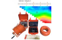
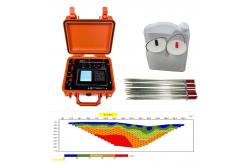
Measurement Data
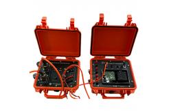
Product Details
Application
By using 1D resistivity sounding, 1D induced polarization sounding, 2D Electrical resistance tomographic, this system is widely used in: 1. Water resources, metal and nonmetal mineral resources detection.
Packing and Delivery
|
||||||||||||||||||||||||||||||||||||||||||||||||||||||||
| Product Tags: Custom 2D Electrical Resistivity Tomography 2D Electrical Resistivity Tomography Geophysical Resistivity System | ||||||||||||||||||||||||||||||||||||||||||||||||||||||||

|
DZD-8A Multi-Function DC Resistivity Meter & Induced Polarization System for Groundwater Exploration and ERT Surveys |

|
Light Weight ≤4.2Kg Geophysical Resistivity Meter with Methodological Flexibility and Research-Grade Data Transparency |

|
Karst Cavity Detection System Environmental Site Investigation Tool Subsurface Contamination Detector |

|
Field-Deployable High Precision Geophysical Resistivity Meter with Educational Resource Package |
|
Geophysical Resistivity Meter with Depth Range 0~1000 meters Compact Size 270mm×246mm×175mm and Max Voltage 1000V |
|
WDJD-4A Geophysical Resistivity Meter with 0-500m Prospecting Depth and Multi-electrode 2D Resistivity Imaging for High Accuracy Surveys |