
51 - 60 of 267
rtk land surveying instruments
Selling leads
|
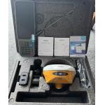
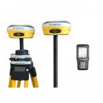
...RTK GNSS Receiver is a high-precision GPS receiver designed for professional surveying applications. With a horizontal accuracy of 2.5mm+0.5ppm RMS...
2025-04-16 07:34:59
|
|
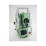
Land Survey Software TS15 total station PUK code tunnel section software product name TS15 total station PUK cod brand Leica model TS15
2025-05-10 00:12:10
|
|
Land Survey Software Leica TCRP1201 total station REF LINE KEY software registration code product name REF LINE KEY brand Leica model TCRP1201
2025-05-10 00:12:10
|
|
Land Survey Software Leica TS06 total station road 2D software registration code product name 2D software registration code brand Leica model TS06
2025-05-10 00:12:10
|

|
Land Survey Software Leica TS09 total station Reference Arc Key software registration code product name Reference Arc Key Brand Leica Model TS09
2025-05-10 00:12:10
|
|
...UI Tilt survey E600 GNSS Receiver The E600 receiver adopts a newly designed, high-precision integrated antenna that can track all current satellite ...
2025-05-10 00:12:10
|

|
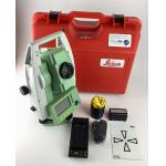
... and land surveying purpose. It comes with battery and its charger and silicon clothing for cover. It is fixed with an electronic distance meter ...
2024-12-09 18:47:22
|
|
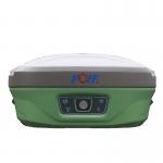
Product Description Top Features With the increasing demand for smart-design GNSS, to develop the receiver featured with miniaturization turns into ...
2025-07-26 00:08:33
|
|
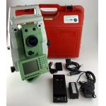
...measuring instrument integrating light, machine and electricity. It is a surveying and mapping instrument system integrating horizontal Angle, ...
2024-12-09 18:47:22
|

|
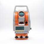
...Japan Topcon total station GM52 surveying instrument KEY FEATURES *Newly Designed High-End Class EDM Especially effective in surveying control ...
2024-12-09 21:05:17
|