
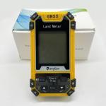
Intelligent GPS Land Measuring Tools for Area and Distance Measuring
|


|
GPS Land Distance Area Measuring Handheld GPS Survey Equipment Unit setting ①On the home page of boot,press the 【Settings】button to enter the settings interface; ②Press the▲▼button move to“unit setting”; ③Press the【Enter】button to enter; ④Press ▲▼ button to choose the unit you want. ⑤After finishing setting,press the power-off button to exit. Note:After setting, the measurement interface data is displayed as the set unit, and the units displayed in the data records are all set units.
The Unit Price ①On the home page of boot,press the 【Settings】button to enter the settings interface; ②Press the▲▼button move to“unit setting”;Press the【Enter】button to enter; ③Press the【Enter】button to choose the unit price; ④Press ▲▼ button to adjust the value of number; ⑤After finishing setting,press the power-off button to exit. Note:After the setting of unit price, the amount can be viewed in the data display of the measurement interface, or in the measurement record details interface.
Parameter setting ①On the home page of boot,press the 【Settings】button to enter the settings interface; ②Press the▲▼button move to“Parameter setting”;Press the【Enter】button to enter; ③Press the【Enter】button to the gradient; ④Press ▲▼ button to adjust the value of number; ⑤After finishing setting,press the power-off button to exit.
Product Parameters Of Handheld GPS Survey Equipment:
|
||||||||||||||||||||||
| Product Tags: Intelligent GPS Land Measuring Tools Distance Measuring GPS Land Measuring Tools Area Measuring Handheld GPS Survey Equipment |

|
S8 Handheld GPS Survey Equipment |

|
Color Screen Handheld GPS Survey Devices |

|
Agriculture Handheld GPS Surveying Equipment |

|
GNSS GPS Agriculture Handheld GPS Survey Equipment High Accuracy |
|
GNSS GPS Regular Irregular Land Distance Area Measuring Device Handheld |

|
Intelligent GPS Land Measuring Tools for Area and Distance Measuring |