
1 - 8 of 8
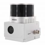
urban 3d application lidar system
Selling leads
|
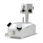
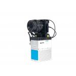
gCollector-M302 Road Information Collection LiDAR Scanning System The gCollector-M302 Road Information Collection system is a mobile real scense ...
2025-07-28 00:13:17
|
|
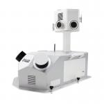
gCollector-M502 Road Information Collection LiDAR Scanning System The gCollector-M502 Road Information Collection system is a mobile real scense ...
2025-07-28 00:13:17
|
|
Smart City Application UAV LiDAR System Geosun GS-130X 3D Surveying And Mapping Hesai XT32 Sensor Applications Of uav LiDAR Scanning System Specificat...
2025-07-28 00:13:17
|
|
...3D Mapping HESAI XT32 Senor UAV LiDAR GS-260X Colored Point Cloud Free Pre-Processing software High Accuracy UAV LiDAR Scanning System GS-260X ...
2025-07-28 00:13:17
|
|
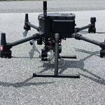
Drone Lidar Scanner Geosun GS-130X 3D Scanning Built-In RGB Camera Total Aerial Solution DJI M300 Cost Effective Application of UAV LiDAR Scanning ...
2025-07-28 00:13:17
|
|
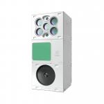
gAirHawk GS-100M+ LIDAR SCANNING SYSTEM Drone LiDAR Scanning System Mounted on DJI M600 Pro Application for Mapping and Survey gAirHawk GS-100M+ is a ...
2025-07-25 11:54:03
|
|
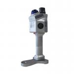
UAV LiDAR Scanning System with Integrated Multispectral Camera Geosun GS-100E LiDAR Scanning System Application for 3D Surveying and Mapping GS-100E ...
2025-07-25 11:54:19
|
|
..., it captures precise 3D point clouds in GNSS or GNSS-denied environments. Its compact design ensures easy mobility for indoor and outdoor mapping, ...
2025-07-25 11:56:20
|