
41 - 44 of 44
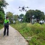
inspection lidar drone
Selling leads
|
Terrain Mapping Drone LiDAR GS-260X Colored Point Cloud High Accuracy Affordable Cost Geosun gAirHawk GS-260X UAV LiDAR Scanning System gAirHawk GS...
2025-07-31 00:16:27
|
|
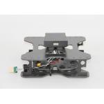
Mounting Kits for DJI M210, M300, M600 Pro and other brands. DJI drones are good application for survey & mapping, especially for DJI M210, M300 and ...
2025-07-25 11:53:58
|
|
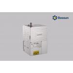
Long Range Laser Scanning VTOL UAV Vehicle Supported Five Echo Colored Point Cloud Free Trajectory Processing gAirHawk GS-1350W is a kind of long ...
2025-07-31 00:16:27
|
|
... or GNSS-denied environments. Its compact design ensures easy mobility for indoor and outdoor mapping, including urban surveys, infrastructure ...
2025-07-25 11:56:20
|