China LiDAR Scanning System manufacturer
Wuhan Geosun Navigation Technology Co., Ltd.
Geosun's Wishes and Aspirations: Make the LiDAR/SLAM Solution More Applicable and Affordable
5
Home > Products > GNSS Solutions >

GPS BDS GLONASS GNSS INS System For Positioning And Altitude

Browse Categories

Wuhan Geosun Navigation Technology Co., Ltd.

City: wuhan

Province/State:hubei

Country/Region:china

Tel:+86--15527360208

Contact Person:
Mr.Lanbooxie
View Contact Details

GPS BDS GLONASS GNSS INS System For Positioning And Altitude

Brand Name Geosun
Model Number AGS 300 Aerial GNSS Receiver
Certification CE, ISO
Place of Origin China
Minimum Order Quantity 1
Price Negotiation
Payment Terms T/T, Western Union, L/C
Supply Ability 30 SETS/Month
Delivery Time 5-10 Working Days Since Payment
Packaging Details Hard Carton 230*160*100 mm
Name GNSS INS System
Application 1 Positioning and Altitude
Application 2 Velocity Measurement
Function 3D Data Collector
Tracking Signal GPS BDS GLONASS
Processor 180 MHz ARM 9 industrial processor
Detailed Product Description

GPS BDS GLONASS GNSS INS System For Positioning And Altitude


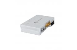
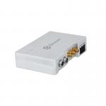
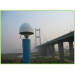
AGS 300 GNSS INS System adds a high-precision inertial navigation (IMU) module, no matter how the fuselage tilts during the aviation flight, it can accurately provide position, velocity and 3D attitude information.

After the data processing of professional software, AGS 300 provides threedimensional position accuracy of 0.05 m, velocity of 0.02 m/s, heading of 0.080 degree, and pitch/roll of 0.030 degree, data sampling rate ups to 200Hz. With AGS 300, UAV Aerial remote sensing can completely be free from ground control point, it is especially applied to the UAV surveying in strip area, irregular shape area, large watershed area and high latitude area; and is also widely used in UAV laser scanning and other direct geo-reference aerial remote sensing fields. For the users who required high-precision and real-time in precision agriculture, electricity and other areas, AGS 300 also offers GNSS real-time differential positioning (RTK) function.


Specification


Tracking SignalGPS: L1 C/A code, L2 C, L1 / L2 ;
BDS : B1, B2a, B3
GLONASS: L1 C/A and P code, L1 /L2 , L2 P code
  
ProcessorProcessor : 180 MHz ARM 9 industrial processor
Build-in RamBuild-in RAM : 2 x 64 MB SDRAM
Build-in FlashBuild-in flash : 4 MB data flash; 1 GB nand flash
SD Card StorageStandard 8 G micro SD card, max support up to 32 GB
Updated rateDefault update rate 5 Hz, max update rate 50 Hz
Storage formatRinex, Binex
Indicator4 LED indicators, same function, indicate GNSS signal and power, 3G connection indicator
and antenna working indicator
PW/EVEN/PPS/RS232One lemon 9 pin interface, one lemon 6 pin double interface
Antenna interfaceOne external antenna interface, one UHF antenna interface, one 3G antenna interface
Mini usb interfaceOne mini USB port
Micro SD card slotOne micro SD card slot
Micro SIM card slotSIM card slot
Dimension (mm)125*85*34
Weight (g)120 , 210 with Cover
Voltage (v)8-26
Power consumption (w)3.3
Working temperature- 20 ℃-- 60 ℃
Storage temperature- 40℃-- 80 ℃
Pitch & Rolling0.025 deg
Heading0.08 deg
Speed0.02 m/s
Positioning Accuracy2-5 cm


Application for Photography


Application for POS Data Post Processing


Product Tags: GLONASS GNSS INS System   BDS GNSS INS System   GPS GNSS INS System  
Related Products
Email to this supplier
 
From:
Enter your Email please.
To: Wuhan Geosun Navigation Technology Co., Ltd.
Subject:
Message:
Characters Remaining: (80/3000)