
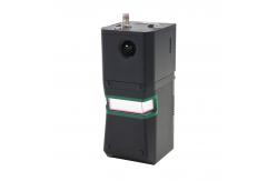
Geosun gAirHawk Series GS-960 LiDAR Scanning System Long Rang Geographic Mapping
|
|
GS-960 LiDAR Scanning System Long Range 750m AGL Geographic Mapping
Geosun gAirHawk Series 960 LiDAR Scanning System gAirHawk GS-960 is a kind of long range, compact LiDAR point cloud data acquisition system, integrated Riegl laser scanner, GNSS and IMU positioning and attitude determination system, and storage control unit, is able to real-time, dynamically, massively collect high-precision point cloud data and rich image information. It is widely used in the acquisition of 3D spatial information in surveying, electricity, forestry, agriculture, land planning.
Specification of LiDAR Scanning System
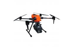
Application of LiDAR Scanning System gAirHawk GS-960
Package of LiDAR Scanning System gAirHawk GS-960
|
|||||||||||||||||||||||||||||||||||||||||||||||||||||||||||||||
| Product Tags: 650m Geographic Mapping Riegl UAV LiDAR 650m AGL Geographic uav mobile mapping system 650m AGL Geographic uav lidar | |||||||||||||||||||||||||||||||||||||||||||||||||||||||||||||||

|
GAirHawk Series GS-1500N LiDAR Scanning System 8 Echos Long Detection Aerial VTOL Mapping |
|
Road Mapping High Precision Mobile LiDAR Geosun gAirHawk GS-260X |

|
Geosun gAirHawk Sesries GS-130X LiDAR Scanning System Hesai XT32 Sensor Strong Penetration 360 Degree Fov |

|
Geosun gAirHawk Series GS-2000N LiDAR Scanning System 7 Echos Long Detection Aerial VTOL Mapping High Accuracy |

|
Geosun gAirHawk Series GS-260H LiDAR Scanning System City Construction 3D Modeling High Accuracy Colored Point Cloud |
|
Geosun gAirHawk GS-100C LiDAR Scanning System Skyport DJI M300 Livox Avia Sensor Colored Point Cloud |