
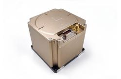
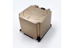
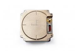
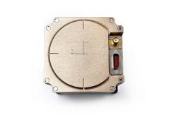
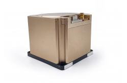
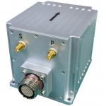
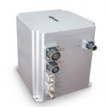
GNSS Fiber Optic Gyroscope , Inertial Navigation System RTK for Marine Navigation
|
|
High Performance Mems lnertial Measurement Unit with Built-in 3 Axis Accelerometer and Gyroscope
The inertial navigation system is installed on a certain type of carrier, which is mainly used to provide angular rate and linear rate information for the carrier. At the same time, it provides navigation information such as angle, speed and position.
a) It can output the angular velocity and linear velocity information of high-speed carrier motion. b) An initial alignment may be made. c) It can be used for inertial navigation and integrated navigation. d) Self-test and debugging function: It has perfect online self-test function to locate the fault to the module and give alarm signals. It has test and maintenance interfaces for software upgrade and output of equipment parameters, and the product has the ability of online upgrade of serial port.
1.1 Accuracy requirements for angular rate measurementa) Angular rate measurement range: ± 500 °/s; b) Zero bias stability at room temperature (1 Sigma 10s smooth): ≤ 0.11 °/h; c) Zero bias stability at high and low temperature constant temperature (1 Sigma 10s smooth): ≤ 0.13 °/h; d) Zero-bias repeatability at room-temperature (1 Sigma): ≤ 0.05 °/h; e) Scale factor non-linearity at room temperature: ≤ 20ppm; f) Scale factor repeatability at room-temperature: ≤ 20ppm; g) Gyro bandwidth: 200Hz (guaranteed by design). h) Startup time of gyro precision guarantee: 10s.
1.2 Accuracy requirements for linear velocity measurementa) Acceleration measurement range: ± 20 g (model selection guarantee) (optional 50g product, slightly lower accuracy); b) Zero bias stability at room temperature (1 Sigma 10s smoothing): ≤ 200ug; c) Zero-bias repeatability at room-temperature(1 Sigma): ≤ 200ug; d) Startup time: 10s.
1.3 Initial alignment accuracy requirementa) Initial alignment mode: it can be used for initial alignment of rocking base, mooring system, satellite-assisted travel, and initial alignment of odometer (or DVL) assisted travel. b) Initial self-alignment heading accuracy of swaying base: 0.25 ° * SecL (L is the local latitude); c) Initial self-alignment pitch accuracy of swaying base: 0.02 °; d) Initial self-alignment rolling accuracy of shaking base: 0.02 °; e) Initial self-alignment time of swaying base: 5min (adaptive modification is allowed, and the recommended initial alignment time of mooring system is 10min); Note: The above alignment accuracy is the result of the corresponding alignment time.
1.4 Satellite failure pure inertial navigation index requirementa) Inertial navigation heading angle hold (drift) accuracy: 0.12 °/h (peak). b) Pitch angle hold (drift) accuracy of inertial navigation: 0.1 °/h (peak). c) Inertial guide roll angle hold (drift) accuracy: 0.1 °/h (peak). d) Measurement range of heading angle: 0 ° ~ 360 ° e) Measurement range of pitch angle: -90 ° ~ + 90 ° f) Rolling angle measurement range: -180 ° ~ + 180 ° g) Positioning accuracy of inertial/odometer integrated navigation: 0.6% D (D is the driving distance). h) Pure inertial horizontal positioning accuracy (surface ship mode): 2500 m (peak-to-peak value, 1 H assessment) i) Pure inertial horizontal positioning accuracy (ground vehicle-mounted mode): 500m (peak-to-peak value, 1H assessment) j) Pure inertial horizontal positioning accuracy (in-flight vehicle-mounted mode): 500m (50% CEP, 10-minute assessment)
1.5 Requirements for effective integrated navigation of satellitea) Satellite integrated navigation heading angle measurement accuracy (fully maneuverable): 0.08 ° (1σ); b) Satellite integrated navigation pitch angle measurement accuracy (fully maneuverable): 0.05 ° (1σ); c) Satellite integrated navigation roll angle measurement accuracy (fully maneuverable): 0.05 ° (1σ); d) Satellite integrated navigation horizontal positioning accuracy (satellite single-point positioning, open environment): 1.5m (1σ) e) Satellite integrated navigation elevation positioning accuracy (satellite single point positioning, open environment): 2.0m (1σ) supports receiving RTCM3.X data, so that the satellite works in RTK state. f) Support access to dual-antenna directional. g) Support access to DVL for INS/DVL integrated navigation. h) Support access to odometer for INS/OD integrated navigation.
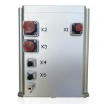
1.6 Power supply requirementsIt is recommended to provide an external DC 28 V power supply with a voltage range of 9 V to 36 V. The steady state power consumption is not more than 9 W.
1.7 Environmental adaptabilitya) Working temperature adaptability: -40 ℃ ~ + 60 ℃; b) Storage temperature adaptability: -45 ℃ ~ + 65 ℃;
|
| Product Tags: Marine Navigation Inertial Navigation System RTK Inertial Navigation System GNSS Fiber Optic Gyroscope |
|
GNSS Fiber Optic Gyroscope , Inertial Navigation System RTK for Marine Navigation |
|
Low Zero Stability Integrated Navigation System With Fiber Gyro And Mems Acceleroemter |
|
Low Cost Mems Integrated Navigation System with RS232/RS422 Output |
|
High Heading Accuracy Gnss Gps Module Rtk Antenna Inertial Navigation System for Marine Navigation |
|
High Precise Inertial Navigation System GPS Inertial Navigation Sensor |
|
Ins500 Fiber Ins Navigation System Closed Loop High Precision |