
Imu Inertial Guidance System , Ins Inertial Navigation System
|
|
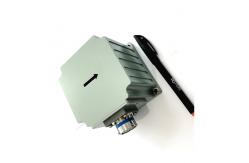
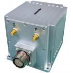
Inertial Guidance System Inertial Guidance System Imu Inertial Navigation System Ins Inertial Navigation System OverviewThe fiber-optic integrated navigation system GI300F-INS is based on closed-loop fiber-optic gyroscope and accelerometer with high cost performance, and is realized through multi-sensor fusion and navigation calculation algorithm, which meets the requirements of precise measurement of attitude, heading and position information in the application fields of medium and high precision mobile measurement systems, medium and large UAVs, etc.
Main functionsThe system has inertial/satellite integrated navigation mode and pure inertial mode. In the inertial/satellite integrated navigation mode, the satellite positioning information received by the external GNSS receiver can be used for integrated navigation, and the pitch, roll, course, position, speed, time and other information of the carrier can be output; After the signal is lost, the position, velocity and attitude calculated by inertia are output, in which the pitch and roll are required to be accurate, the course keeping function is available in a short time, and the meter-level positioning accuracy is available in a short time. After the pure inertial mode (that is, GPS fusion has never been performed after power-on, and if it loses lock again after fusion, it belongs to the integrated navigation mode) is started, it has the function of accurate attitude measurement, can output the pitch and roll heading, and the pure inertial mode can find the north statically.
Size: The integrated design scheme is adopted for the inertial measurement unit, and the system outline is shown in the figure below. The overall dimension of the system is 92.0 mm × 92.0 mm × 81.0 mm (length × width × height). d the other end is divided into a power supply red and black clip and three serial ports, which are COM1 ~ COM3, where COM1 is RS422, COM2 and COM3 are RS232. COM 1 can be used to send the working mode command; |
||||||||||||||||||||||||||||||||||||||||||||||||||||||||||||||||||||||||
| Product Tags: Imu Inertial Guidance System Ins Inertial Guidance System Inertial Navigation System with GPS | ||||||||||||||||||||||||||||||||||||||||||||||||||||||||||||||||||||||||
|
GNSS Fiber Optic Gyroscope , Inertial Navigation System RTK for Marine Navigation |
|
Low Zero Stability Integrated Navigation System With Fiber Gyro And Mems Acceleroemter |
|
Low Cost Mems Integrated Navigation System with RS232/RS422 Output |
|
High Heading Accuracy Gnss Gps Module Rtk Antenna Inertial Navigation System for Marine Navigation |
|
High Precise Inertial Navigation System GPS Inertial Navigation Sensor |
|
Ins500 Fiber Ins Navigation System Closed Loop High Precision |