China Accelerometer Gyro Sensor manufacturer
Shenzhen Fire Power Control Technology Co., LTD
4
Home > Products > Inertial Navigation System >

High End GNSS Receiver MEMS Inertial Navigation System for Surveying and Mapping

Browse Categories

Shenzhen Fire Power Control Technology Co., LTD

City: shenzhen

Province/State:guangdong

Country/Region:china

Tel:86-755-23097872

View Contact Details

High End GNSS Receiver MEMS Inertial Navigation System for Surveying and Mapping

Brand Name AVIC
Model Number GI300C
Certification CE ROHS
Place of Origin CHINA
Minimum Order Quantity 1
Price negotiable
Payment Terms T/T
Supply Ability 500/month
Delivery Time 10 days
Packaging Details sponge+carton
Product name MEMS Inertial Navigation System
Attitude accuracy 0.02deg (rms)
Heading precision 0.1deg (rms)
Gyro range ±400°/s
Gyro zero bias stability ≤0.3°/h
Accelerometer range ±20g
Accelerometer zero bias stability ≤100µg
Interface RS232/RS422/PPS
Power consumption ≤8W
Operating temperature -40℃~+60℃
Detailed Product Description

High End GNSS Receiver MEMS Inertial Navigation System for Surveying and Mapping


Product Description


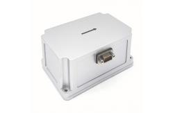
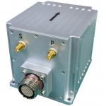
GI300C is a compact inertial navigation system with fiber optic gyroscope (FOG) and micro-electromechanical system (MEMS) accelerometers, which can use external GNSS accurate timing and positioning information for inertial/satellite integrated navigation. When the external GNSS information is invalid, the inertial navigation system has a high ability to maintain the accuracy of pure inertial navigation.


Main Application 

  • Drone
  • Rocket
  • Mobile measurement
  • Detection and measurement of ground, tunnel and other tracks
  • High precision stable platform

Main Function

  • Shaking base/moving base alignment function
  • Self-seeking north
  • Outer GNSS/atmosphere multi-information fusion integrated navigation
  • Longer time accuracy retention without external information assistance
  • Support users to customize on demand


Technical Indicators
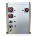
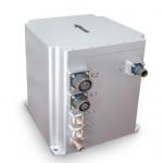
 

ProjectTest conditionsIndicators
Positioning accuracyExternal GNSS Valid, Single PointBetter than external satellite positioning accuracy
External GNSS Valid, RTKBetter than external satellite positioning accuracy
Pure inertial horizontal position holding 100m/5min(CEP)
600m/10min(CEP)
2nm/30min(CEP)
Airspeed combined horizontal position hold 1nm/30min (CEP)
Heading accuracySingle antenna0.1°
Dual antenna0.2 °/L (L = baseline length) (RMS)
Heading holding0.3°/30min(RMS),1°/h(RMS)
Self-north seeking accuracy1 ° SecL, alignment 15min
Attitude accuracyGNSS is valid0.02°(RMS)
Attitude hold (GNSS failure)0.3°/30min(RMS),1°/h(RMS)
Speed accuracyGNSS valid, single point L1/L20.1m/s(RMS)
Gyro rangeMeasuring range±400°/s
Zero bias stability≤0.3°/h
AccelerometerMeasuring range±20g
Zero bias stability≤100µg
Physical dimensions and electrical characteristicsVoltage9-36V DC
Power consumption≤8W
Interface2-channel RS232, 1-channel RS422, 1-channel PPS (lVTTL/422 level)
Size111mm × 72mm × 43mm (L, W, H)
Weight≤450g
Environmental characteristicsOperating temperature-40℃~+60℃
Storage temperature-45℃~+70℃
Vibration5 ~ 2000Hz, 6.06 G (with shock absorber)
Impact30g, 11 ms (with shock)
Life span> 15 years
Continuous working time>24h
Note:

① The alignment is valid;

② For airborne use, there is a turning maneuver before the airspeed combination, and the test takes the  flight speed of 150km/H as an example;

③ On-board conditions, need to be mobile;

④ Two-position alignment, the heading difference between the two positions is greater than 90 degrees


Product Stuucture


                       L111mm x W72mm x H42.8mm(L x W x H)


Product Tags: MEMS Inertial Navigation System   Inertial Navigation System for Surveying   Inertial Navigation System for Mapping  
Related Products
Email to this supplier
 
From:
Enter your Email please.
To: Shenzhen Fire Power Control Technology Co., LTD
Subject:
Message:
Characters Remaining: (80/3000)